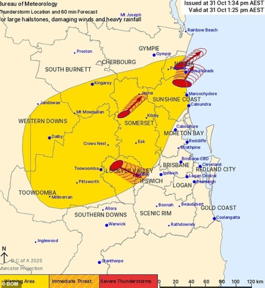
يستعد سكان جنوب شرق كوينزلاند في أستراليا لموجة من العواصف الشديدة المحتملة، بما في ذلك إعصار معزول، مع اقتراب خلية جوية مدمرة من المنطقة، وفقاً لتحذيرات مكتب الأرصاد الجوية الأسترالي (BOM).
وصدرت تحذيرات عواصف رعدية لمناطق إيبسويتش، سومرست، وادي لوكيير، وساحل الشمس في كوينزلاند لنهاية الأسبوع، مع تركيز التحذير الأشد على أجزاء من وايد باي وبيرنيت، دارلينغ داونز، غرانيت بيلت، وساحل الجنوب الشرقي.
رياح مدمرة وأمطار غزيرة
وتتحرك الرياح المدمرة، والأمطار الغزيرة، والبراد الإعصاري الكبير إلى شمال شرق شاطئ كولوم على ساحل الشمس نحو رأس نوسا، وتمر العاصفة حالياً عبر يوماندي إلى تيوانتين، ومناطق مور ولينفيل في منطقة سومرست، إضافة إلى هيليدون، غاتون، غرانثام، لايدلي، غرانتشيستر، ومولغوي، التي تقع جميعها في مسار العاصفة.
وأفاد موقع «ويذرزون» المتخصص في الأرصاد بأن المناطق الأكثر تضرراً قد تواجه هذه الخلية السوبرية لمدة تصل إلى 6 أيام، ما يجعلها واحدة من أطول الفترات الجوية الشديدة في السنوات الأخيرة.
عاصفة تستمر 6 أيام
وأكد عالم الأرصاد في «ويذرزون»، بن دومينسينو، أن العواصف قد تستمر لـ6 أيام، مع ذروتها يوم السبت، وقال: «قد تتطور العواصف صباحاً مبكراً في أجزاء شرقية من نيو ساوث ويلز وكوينزلاند يوم السبت، قبل أن تصبح أكثر انتشاراً وشدة خلال الظهيرة والمساء».
كما ستكون العواصف الأكثر نشاطاً بين وسط شرق كوينزلاند ووسط نيو ساوث ويلز، وقد تشمل بريسبن وسيدني، ومن الممكن حدوث عواصف سوبر سيل، ولا يمكن استبعاد إعصارات معزولة».
فيما أشار مقدم الطقس في مكتب الأرصاد جوناثان هاو إلى أن السبت سيكون الأسوأ في الأسبوع، وقال: «جميع عواصف السوبر سيل تحمل مخاطر طفيفة للإعصارات، لكننا سنصدر تحذيراً فقط إذا تلقينا تقارير موثوقة».
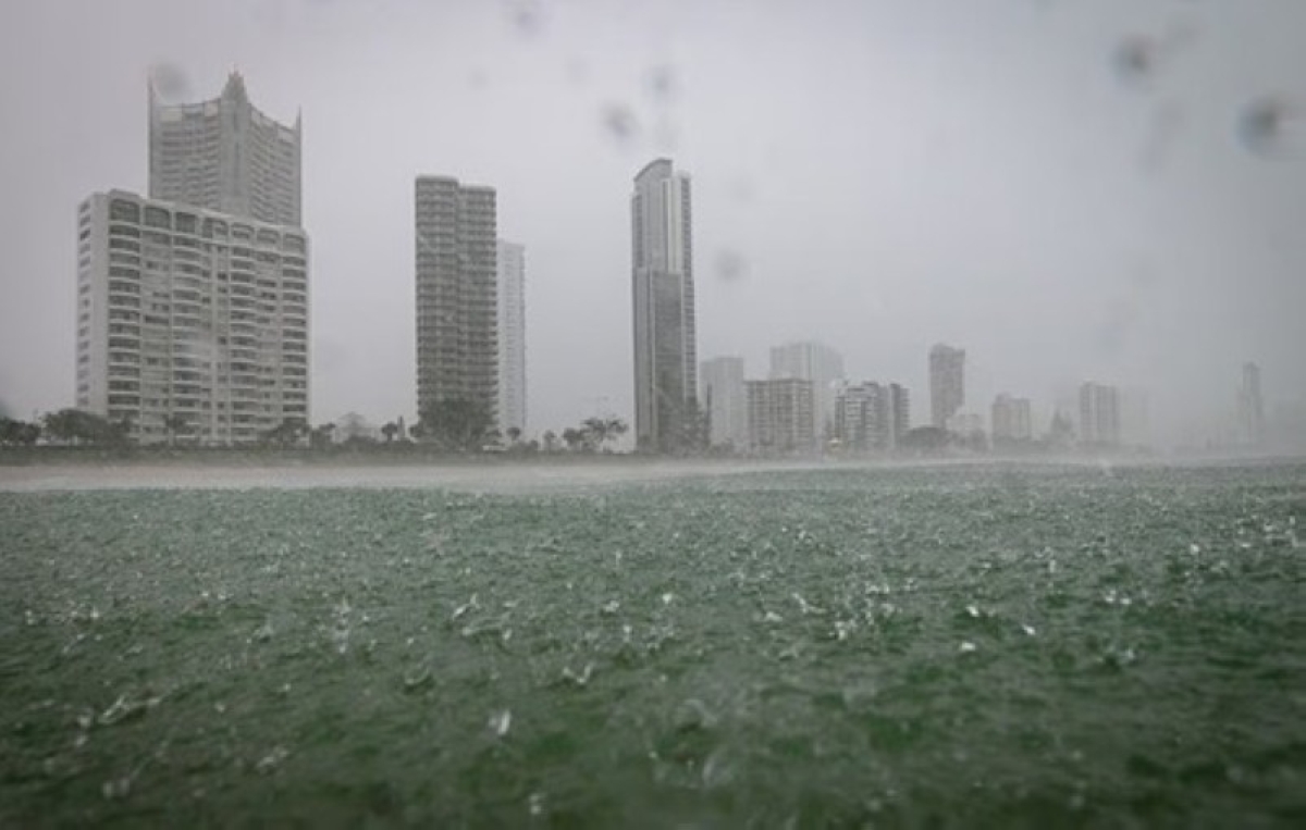
وتُشير توقعات الأمطار إلى سقوط ما يصل إلى 30 ملم في بريسبن، و25 ملم على ساحل الشمس وغولد كوست.
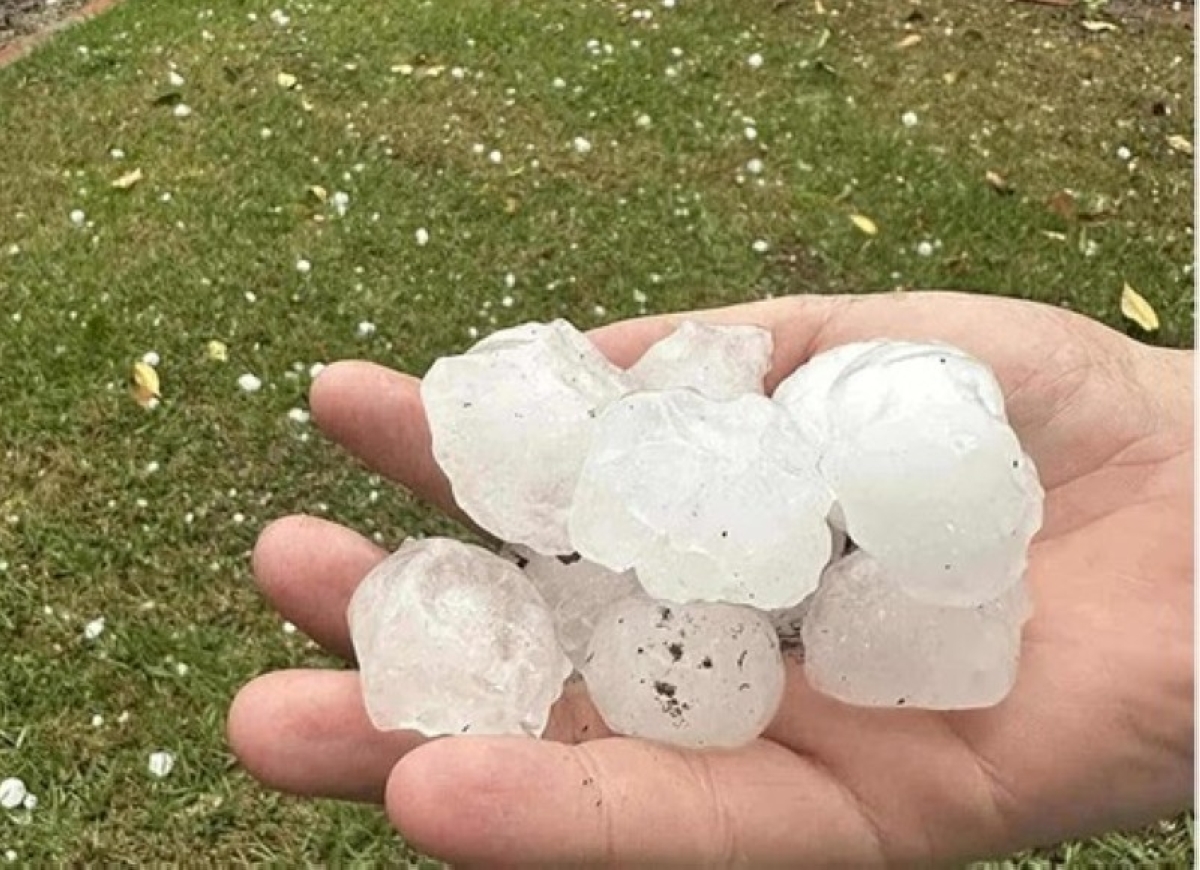
وتأتي هذه العواصف بعد أيام قليلة فقط من ضرب الولاية بحجارة برد بحجم كرات الغولف، التي أدت إلى انقطاعات كهرباء واسعة في بريسبن الكبرى ليوم كامل تقريباً، حيث تأثر أكثر من 100 ألف منزل، وأدت إلى إغلاق شبكة الكهرباء في المنطقة.
وفي الوقت الحالي، أثرت العاصفة الأخيرة على نحو 8 آلاف منزل، مع توقعات بتأثر المزيد مع استمرار الضغط على الشبكة الكهربائية.
وتنجم هذه العواصف عن جرف علوي قد يؤدي إلى أيام من الأمطار الغزيرة، ومن المتوقع أن يؤثر على وسط وشرق وجنوب شرق أستراليا مطلع الأسبوع القادم، فيما حذر مكتب الأرصاد ملايين السكان من الاستعداد لعواصف سوبر سيل وإعصارات معزولة محتملة خلال الـ24 ساعة القادمة، وقد مرت 7 عواصف شديدة عبر الجنوب الشرقي أو تتحرك حالياً فيه.
وفي الأحد الماضي، ضربت عواصف عنيفة جنوب شرق كوينزلاند بحجارة برد عملاقة ورياح مدمرة، ما أدى إلى انقطاع الكهرباء عن عشرات الآلاف من المنازل. ومع ذلك، يستمر التنظيف من العواصف السابقة بينما تقترب الموجة الجديدة، مع تسجيل رياح بسرعة 96 كم/ساعة وحجارة برد تصل إلى 5 سنتيمترات في بعض المناطق.
ويحث الخبراء السكان على الاستعداد، مثل تأمين الممتلكات والمتابعة الدقيقة للتحذيرات، خصوصاً مع انتقال النمط الجوي إلى شكل صيفي يومي يحمل مخاطر عواصف.
Residents of Southeast Queensland in Australia are preparing for a potential wave of severe storms, including an isolated cyclone, as a destructive weather cell approaches the area, according to warnings from the Australian Bureau of Meteorology (BOM).
Severe thunderstorm warnings have been issued for the areas of Ipswich, Somerset, Lockyer Valley, and the Sunshine Coast in Queensland for the weekend, with the most intense warnings focused on parts of Wide Bay and Burnett, Darling Downs, Granite Belt, and the southeast coast.
Destructive Winds and Heavy Rain
Destructive winds, heavy rain, and large hail are moving northeast from Coolum Beach on the Sunshine Coast towards Noosa Heads, with the storm currently passing through Duyfken to Tewantin, and affecting the areas of Moor and Linville in Somerset, as well as Helidon, Gatton, Grantham, Laidley, Granchester, and Mulgowie, all of which are in the storm's path.
The specialized weather site "Weatherzone" reported that the most affected areas could experience this supercell for up to 6 days, making it one of the longest periods of severe weather in recent years.
Storm Lasting 6 Days
Weather scientist at "Weatherzone," Ben Domensino, confirmed that the storms could last for 6 days, peaking on Saturday, stating: "Storms may develop early in the morning in eastern parts of New South Wales and Queensland on Saturday, before becoming more widespread and intense during the afternoon and evening."
The most active storms will be between Central Eastern Queensland and Central New South Wales, potentially affecting Brisbane and Sydney, with the possibility of supercell storms, and isolated cyclones cannot be ruled out.
Weather presenter at the Bureau of Meteorology, Jonathan Howe, noted that Saturday will be the worst day of the week, saying: "All supercell storms carry a slight risk of cyclones, but we will only issue a warning if we receive reliable reports."
Rainfall forecasts indicate up to 30 mm in Brisbane and 25 mm on the Sunshine Coast and Gold Coast.
These storms come just days after the state was hit by golf ball-sized hail, which caused widespread power outages in Greater Brisbane for almost a full day, affecting over 100,000 homes and leading to the shutdown of the power grid in the area.
Currently, the latest storm has affected around 8,000 homes, with more expected to be impacted as pressure on the power grid continues.
These storms are caused by an upper-level trough that could lead to days of heavy rain, expected to affect Central, Eastern, and Southeastern Australia early next week, while the Bureau of Meteorology warned millions of residents to prepare for potential supercell storms and isolated cyclones in the next 24 hours, with 7 severe storms having passed through or currently moving through the southeast.
Last Sunday, violent storms struck Southeast Queensland with giant hail and destructive winds, causing power outages for tens of thousands of homes. However, cleanup from the previous storms continues as the new wave approaches, with winds recorded at 96 km/h and hail reaching 5 centimeters in some areas.
Experts are urging residents to prepare, such as securing property and closely monitoring warnings, especially as the weather pattern shifts to a daily summer-like form that carries storm risks.