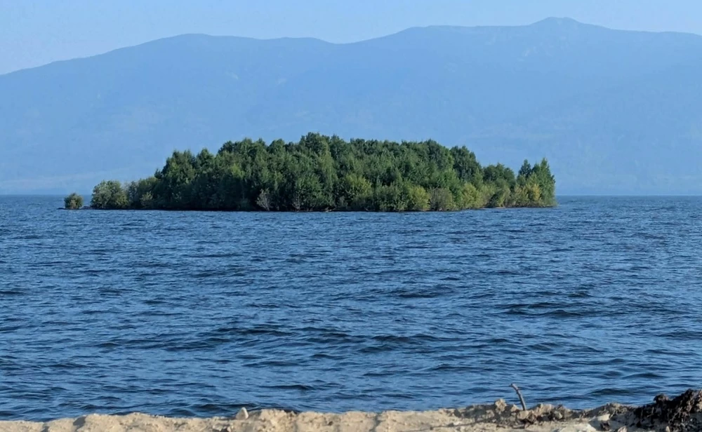
في مشهد بدا للوهلة الأولى وكأنه من فيلم خيالي، ظهرت جزيرة صغيرة مغطاة بالأشجار وهي تطفو فوق مياه خزان (ويليستون) في كولومبيا البريطانية بكندا، قبل أن تختفي بصورة مفاجئة، تاركة السكان والسلطات في حيرة بشأن مصدرها ومصيرها.
وبحسب بيانات شركة (بي سي هايدرو) المسؤولة عن تشغيل الخزان، بلغ طول الكتلة العائمة نحو 140 مترًا وعرضها 70 مترًا، بمساحة تقدر بنحو 9800 متر مربع؛ أي ما يقارب مساحة ملعبين لكرة القدم الأمريكية.
والتقط أحد السكان المحليين صورًا ومقطع فيديو للجزيرة أثناء وجوده في المنطقة، قبل أن تصل الصور إلى روكي إيفري، الذي نشرها على مواقع التواصل الاجتماعي في أغسطس، لتنتشر على نطاق واسع وتثير تساؤلات حول كيفية ظهور كتلة بهذا الحجم في وسط خزان مائي شاسع.
وقال إيفري إنه لم يرَ شيئًا مماثلًا خلال نحو 40 عامًا قضاها في المنطقة، مؤكدًا أن المشهد كان لافتًا للغاية، وأن نشر الصور جاء أيضًا بهدف تنبيه شركة الكهرباء تحسبًا لتحرك الكتلة العائمة باتجاه السد.
وفي البداية، لم تستبعد شركة (بي سي هايدرو) احتمال أن تكون الصور أو المقاطع مفبركة أو مولدة بالذكاء الاصطناعي، خصوصًا في ظل انتشار المحتوى المزيف على الإنترنت، وعدم وجود بلاغات كثيرة بشأن الجزيرة.
لكن الشك تبدد بعد مراجعة صور الأقمار الصناعية؛ إذ أظهرت صورة التقطها القمر الصناعي (سنتينل-2) التابع لوكالة الفضاء الأوروبية في 21 يوليو الماضي وجود الكتلة العائمة بالفعل، على بعد نحو 100 كيلومتر غرب سد «دبليو إيه سي بينيت».
غير أن المفاجأة الأكبر جاءت لاحقًا، بعدما اختفت الجزيرة من صور الأقمار الصناعية الحديثة، ولم تتمكن الشركة من تحديد مكانها الجديد. وأكد المتحدث باسم (بي سي هايدرو) بوب غامر أن اختفاءها من الصور لا يعني بالضرورة أنها غرقت، مرجحًا أن تكون عادت إلى منطقة أكثر حماية بمحاذاة الشاطئ.
والتفسير الأكثر ترجيحًا لدى الشركة لا يتحدث عن تشكل جزيرة جديدة بفعل النشاط الجيولوجي، وإنما عن كتلة ضخمة من الأخشاب والحطام العضوي تراكمت على أطراف الخزان لسنوات، ونمت عليها الأشجار والنباتات، قبل أن تنفصل عن الشاطئ وتتحول إلى كتلة عائمة.
وجاء ذلك بعد ارتفاع منسوب خزان (ويليستون) إلى أعلى مستوياته منذ 14 عامًا، وهو ما قد يكون أدى إلى رفع حطام وأخشاب كانت مستقرة في مناطق ضحلة أو محمية، ثم دفعها بعيدًا عن الشاطئ بفعل المياه والرياح.
وعلى الرغم من استمرار الغموض حول التفاصيل الدقيقة لكيفية تشكل الكتلة وتحركها، ظهرت تطورات جديدة في نهاية أغسطس عندما أعلن إيفري العثور عليها مرة أخرى، لكن هذه المرة في نهر أوسبيكا الذي يصب في خزان (ويليستون)، ما يشير إلى أنها لم تختفِ فعليًا وإنما تحركت إلى موقع آخر.
ويُعد خزان (ويليستون) أحد أضخم الخزانات الاصطناعية في العالم، وهو الأكبر من نوعه في كولومبيا البريطانية، وقد نشأ خلف سد (دبليو إيه سي بينيت) ويغطي مساحة هائلة تجعل تعقب كتلة عائمة بهذا الحجم أمرًا بالغ الصعوبة.
In a scene that initially seemed like something out of a fantasy film, a small island covered in trees appeared floating on the waters of the Williston Reservoir in British Columbia, Canada, before suddenly disappearing, leaving residents and authorities puzzled about its origin and fate.
According to data from BC Hydro, the company responsible for operating the reservoir, the floating mass was approximately 140 meters long and 70 meters wide, covering an area estimated at around 9,800 square meters; roughly the size of two American football fields.
A local resident captured photos and a video of the island while in the area, before the images reached Rocky Every, who shared them on social media in August, leading to widespread attention and questions about how such a large mass appeared in the middle of a vast body of water.
Every stated that he had not seen anything like it during the nearly 40 years he spent in the area, emphasizing that the scene was very striking, and that sharing the photos was also intended to alert the power company in case the floating mass moved toward the dam.
Initially, BC Hydro did not rule out the possibility that the photos or videos were fabricated or generated by artificial intelligence, especially given the prevalence of fake content online and the lack of numerous reports regarding the island.
However, doubts were dispelled after reviewing satellite images; a photo taken by the Sentinel-2 satellite of the European Space Agency on July 21 showed the floating mass indeed existed, about 100 kilometers west of the W.A.C. Bennett Dam.
Yet the bigger surprise came later when the island disappeared from recent satellite images, and the company was unable to determine its new location. BC Hydro spokesperson Bob Gammer confirmed that its disappearance from the images did not necessarily mean it had sunk, suggesting it may have returned to a more sheltered area along the shore.
The most likely explanation from the company does not involve the formation of a new island due to geological activity, but rather a massive accumulation of wood and organic debris that had built up at the edges of the reservoir over the years, which then grew trees and plants before breaking away from the shore and becoming a floating mass.
This occurred after the water level of the Williston Reservoir rose to its highest point in 14 years, which may have lifted debris and wood that were stable in shallow or protected areas, then pushed them away from the shore due to water and wind.
Despite the ongoing mystery surrounding the precise details of how the mass formed and moved, new developments emerged at the end of August when Every announced he had found it again, but this time in the Osbika River, which flows into the Williston Reservoir, indicating that it had not actually disappeared but had moved to another location.
The Williston Reservoir is one of the largest artificial reservoirs in the world and the largest of its kind in British Columbia, having formed behind the W.A.C. Bennett Dam and covering a vast area that makes tracking a floating mass of this size extremely difficult.