رفعت السلطات الإندونيسية، أمس (الأربعاء)، مستوى التحذير من جبل بور ني تيلونج، في مقاطعة آتشيه غربي البلاد إلى المستوى الثاني الأعلى، بعد تسجيل زيادة حادة ومستمرة في النشاط البركاني، شملت سلسلة من الهزات الأرضية البركانية المتكررة.
وأعلن مركز علم البراكين وتخفيف مخاطر الكوارث الجيولوجية التابع لوزارة الطاقة والثروة المعدنية أن الرفع جاء بعد رصد 7 هزات بركانية ضحلة و14 هزة بركانية عميقة، إلى جانب هزتين تكتونيتين، خلال الساعات التي سبقت القرار مساء الثلاثاء.
كما سُجلت 7 هزات أرضية محسوسة بين الساعة 20:43 و22:45 مساءً، شعر بها السكان على بعد نحو 5 كيلومترات جنوب غرب القمة.
10 عقود من الهدوء
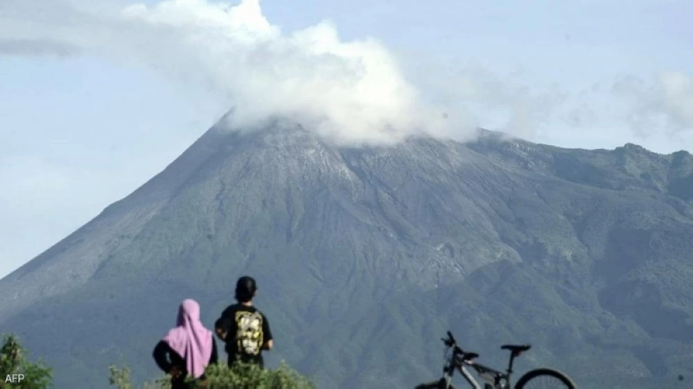
وجبل بور ني تيلونج هو بركان طبقي يرتفع إلى 2624 متراً فوق سطح البحر، ويقع في مقاطعة بينر ميرياه بآتشيه، ويُعد من البراكين النشطة تاريخياً، وكان آخر ثوران مسجل عام 1924.
وبدأت علامات النشاط المتزايد منذ يوليو الماضي، مع تسجيل نحو 10 هزات بركانية عميقة حتى نهاية ديسمبر، إلا أن النشاط أصبح أكثر كثافة وأقل عمقاً خلال نوفمبر وديسمبر، ما يشير إلى حركة محتملة للماغما داخل البركان.
وأظهرت المراقبة البصرية من قبل الوكالة أن البركان مرئي بشكل واضح ولا ينبعث دخان من فوهته، ورغم ذلك حذرت من ثوران محتمل، بما في ذلك انفجارات جوفية وانبعاث غازات بركانية خطرة بالقرب من المناطق التي تحتوي على فوهات بركانية تنبعث منها الأبخرة والغازات.
مخاوف من انفجار مفاجئ
أوضحت لانا ساريا، القائمة بأعمال رئيس وكالة الجيولوجيا، أن النشاط المغناطيسي «سهل التحفيز» بسبب الاضطرابات التكتونية المحيطة بمنطقة آتشيه، ما يزيد من احتمالية حدوث انفجار فجائي أو انفجار مدفوع بضغط الماغما.
وأعلنت السلطات الإندونيسية عن مجموعة من الإجراءات الاحترازية من بينها حظر الاقتراب من نطاق 4 كيلومترات حول القمة، وطُلب من السكان في المناطق المجاورة البقاء هادئين واتباع تعليمات السلطات المحلية، وإجلاء مئات السكان من قرى ريمبوني وكامبونغ بانتان بيديانغان في كيتشامات تيمانغ غاجاه، ونقلوا إلى ملاجئ مؤقتة (بما في ذلك مجمع جامعة سياه كوالا).
وأكد مركز علم البراكين استمرار عمل المراقبين على مدار الساعة لتتبع التغيرات في الزلازل والغازات، مع تحذير من أن الوضع قد يتطور بسرعة.
وتقع إندونيسيا على حزام النار في المحيط الهادئ، وتضم أكثر من 120 بركاناً نشطاً، ما يجعلها من أكثر الدول عرضة للنشاط البركاني في العالم.
The Indonesian authorities raised the alert level for Mount Bur Ni Telong in Aceh province, western Indonesia, to the second highest level yesterday (Wednesday), following a sharp and continuous increase in volcanic activity, which included a series of repeated volcanic tremors.
The Center for Volcanology and Geological Hazard Mitigation under the Ministry of Energy and Mineral Resources announced that the elevation came after monitoring 7 shallow volcanic tremors and 14 deep volcanic tremors, along with two tectonic tremors, during the hours leading up to the decision on Tuesday evening.
Additionally, 7 felt tremors were recorded between 8:43 PM and 10:45 PM, which were sensed by residents about 5 kilometers southwest of the summit.
10 Years of Calm
Mount Bur Ni Telong is a stratovolcano that rises to 2,624 meters above sea level, located in the Bener Meriah district of Aceh, and is considered historically active, with the last recorded eruption occurring in 1924.
Signs of increased activity began in July, with about 10 deep volcanic tremors recorded until the end of December, but the activity became more intense and less deep during November and December, indicating potential magma movement within the volcano.
Visual monitoring by the agency showed that the volcano is clearly visible and no smoke is emitted from its crater; however, it warned of a potential eruption, including explosive eruptions and the emission of hazardous volcanic gases near areas with craters emitting steam and gases.
Concerns of a Sudden Explosion
Lana Saria, the acting head of the Geological Agency, explained that the magnetic activity is "easily triggered" due to the tectonic disturbances surrounding the Aceh region, increasing the likelihood of a sudden explosion or an explosion driven by magma pressure.
The Indonesian authorities announced a series of precautionary measures, including a ban on approaching within a 4-kilometer radius around the summit, and residents in nearby areas were asked to remain calm and follow local authorities' instructions, with hundreds of residents evacuated from the villages of Rimboni and Kampung Pantan Bediang in the Timang Gajah sub-district, and moved to temporary shelters (including the Syiah Kuala University complex).
The Center for Volcanology confirmed that observers are working around the clock to monitor changes in seismic activity and gases, warning that the situation could evolve rapidly.
Indonesia is located on the Pacific Ring of Fire and has more than 120 active volcanoes, making it one of the most volcanically active countries in the world.