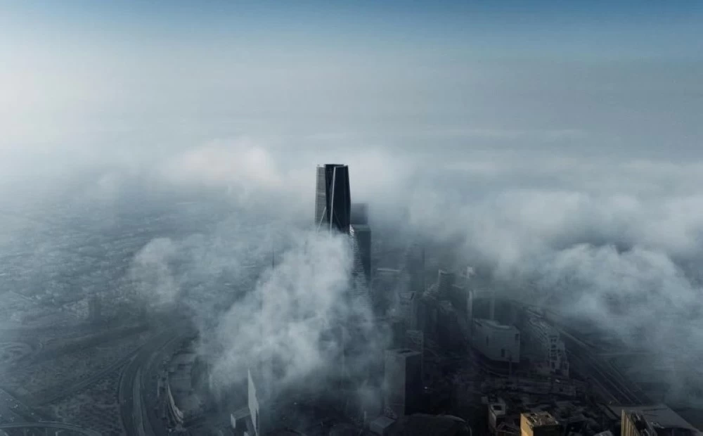
توقّع المركز الوطني للأرصاد في تقريره عن حالة الطقس لهذا اليوم (الأحد)، استمرار تأثير الرياح النشطة المثيرة للأتربة والغبار على أجزاء من مناطق مكة المكرمة، المدينة المنورة وتبوك خصوصا الساحلية منها، في حين لاتزال الفرصة مهيأة لتكون الضباب على أجزاء من مناطق الحدود الشمالية، الجوف، حائل، القصيم، الرياض والشرقية.
ووفقًا للمركز، ستكون حركة الرياح السطحية على البحر الأحمر، شمالية شرقية إلى شمالية بسرعة 15-35 كم/ساعة على الجزء الشمالي والأوسط، وجنوبية شرقية إلى شرقية بسرعة 20-40 كم/ساعة على الجزء الجنوبي تصل إلى 50 كم/ساعة باتجاه مضيق باب المندب، وارتفاع الموج من نصف المتر إلى متر ونصف على الجزء الشمالي والأوسط ومن متر إلى مترين على الجزء الجنوبي يصل إلى أعلى من مترين باتجاه مضيق باب المندب، وحالة البحر خفيف إلى متوسط الموج يصل إلى مائج باتجاه مضيق باب المندب.
وعلى الخليج العربي ستكون حركة الرياح السطحية شمالية شرقية إلى جنوبية شرقية بسرعة 16-36 كم/ساعة تصل إلى أكثر من 50 كم/ساعة مع تكون السحب الرعدية الممطرة على الجزء الجنوبي، وارتفاع الموج من نصف المتر إلى متر ونصف يصل إلى أعلى من مترين مع تكون السحب الرعدية الممطرة على الجزء الجنوبي، وحالة البحر خفيف إلى متوسط الموج يصل إلى مائج مع تكون السحب الرعدية الممطرة على الجزء الجنوبي.
The National Center of Meteorology expected in its weather report for today (Sunday) that the impact of active winds stirring up dust and sand will continue in parts of the Makkah, Madinah, and Tabuk regions, especially along the coast. Meanwhile, the opportunity remains for fog formation in parts of the Northern Borders, Al-Jawf, Ha'il, Al-Qassim, Riyadh, and the Eastern Province.
According to the center, the surface wind movement over the Red Sea will be from the northeast to the north at a speed of 15-35 km/h in the northern and central parts, and from the southeast to the east at a speed of 20-40 km/h in the southern part, reaching up to 50 km/h towards the Bab el-Mandeb Strait. The wave height will range from half a meter to one and a half meters in the northern and central parts, and from one meter to two meters in the southern part, reaching over two meters towards the Bab el-Mandeb Strait. The sea condition will be light to moderate, becoming rough towards the Bab el-Mandeb Strait.
In the Arabian Gulf, the surface wind movement will be from the northeast to the southeast at a speed of 16-36 km/h, reaching over 50 km/h with the formation of thunderstorm clouds bringing rain in the southern part. The wave height will range from half a meter to one and a half meters, reaching over two meters with the formation of thunderstorm clouds bringing rain in the southern part. The sea condition will be light to moderate, becoming rough with the formation of thunderstorm clouds bringing rain in the southern part.