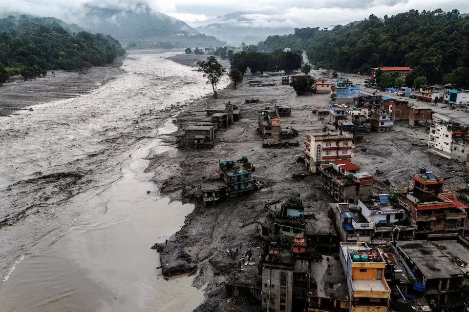
كشفت تفاصيل اجتماع عقدته نيبال والصين قبل أشهر من كارثة الفيضانات المدمرة في منطقة الهيمالايا عن تحديات تواجه البلدين في تبادل المعلومات المتعلقة بمخاطر الأنهار الجليدية والفيضانات، في وقت تسعى فيه كاتماندو إلى تعزيز قدراتها على الإنذار المبكر والاستجابة للكوارث، بحسب تقرير لوكالة «رويترز».
وقبل نحو ثلاثة أشهر من اجتياح جدار هائل من المياه والطين والصخور أحد الأودية على الحدود بين البلدين، عقد مسؤولون وخبراء من نيبال والصين اجتماعًا في العاصمة كاتماندو في 27 مايو، لبحث مخاطر الفيضانات والطقس والأنهار الجليدية.
وبحسب جدول أعمال للاجتماع، شارك نحو عشرة مسؤولين من كل جانب، بينهم ممثلون عن منطقة التبت التي شهدت الكارثة لاحقًا.
وناقش المشاركون تعزيز التعاون في مراقبة المخاطر والاستجابة لها، إلى جانب إعداد قوائم بالبحيرات الجليدية ورسم خرائط للمناطق المعرضة للخطر.
لكن مسؤولين نيباليين قالوا إن بلادهما لم تحصل بعد الاجتماع على القدر الذي كانت تريده من المعلومات الصينية بشأن مخاطر الأنهار الجليدية ومستويات المياه، ما أثار مخاوف بشأن القدرة على توقع الكوارث الكبرى والاستعداد لها.
وقال ساوهاردرا جوشي، خبير الهيدرولوجيا النيبالي الذي شارك في الاجتماع، إن بلاده تريد معرفة أي تحركات مبكرة للأنهار الجليدية أو تغيرات في المنطقة.
الصين: قدمنا المعلومات في الوقت المناسب
لم يحمّل المسؤولون والخبراء في البلدين أي طرف مسؤولية الكارثة، فيما أكدت نيبال أن أولويتها الحالية هي تعزيز التعاون مع الصين.
وقالت السفارة الصينية في نيبال، في بيان نشرته عبر منصة «إكس»، إن بكين وكاتماندو حافظتا على اتصال وثيق، وإن اجتماع مايو حقق «تقدمًا جوهريًا» في تعزيز تبادل معلومات الكوارث العابرة للحدود.
ورفضت السفارة انتقادات ظهرت على وسائل التواصل الاجتماعي في نيبال تتهم الصين بعدم تقديم تحذيرات كافية، مؤكدة أن فرق الرصد تواجه تحديات كبيرة في المناطق النائية من جبال الهيمالايا، وأن الفرق الصينية شاركت معلومات مهمة مع نيبال «في الوقت المناسب».
وقال خبير الهيدرولوجيا الحكومي بينود باراجولي إن الصين تشارك نيبال توقعات الأمطار الغزيرة في منطقة التبت وبعض بيانات الرصد، لكن تبادل المعلومات لا يشمل بالقدر نفسه بيانات عن الانهيارات الثلجية ومستويات المياه والانهيارات الأرضية والظواهر الجوية المتطرفة.
وأضاف أن الصين بدأت قبل شهر في إرسال توقعات الأمطار الغزيرة عبر تطبيق «ويتشات» والبريد الإلكتروني.
تحذير صيني قبل 12 يومًا من الكارثة
وقبل 12 يومًا من وقوع الكارثة الأخيرة، أرسل المركز العالمي للأرصاد الجوية في الصين رسالة إلكترونية إلى مسؤولين نيباليين حذر فيها من منخفض موسمي متوقع بين 14 و19 أغسطس، مع توقع زيادة الأمطار في مناطق واسعة من نيبال واحتمال حدوث انهيارات أرضية وسيول مفاجئة.
لكن الكارثة كشفت أيضًا عن صعوبات في أنظمة الرصد، فبعد اجتياح المياه الحدودية في التبت نحو الساعة 8:32 صباحًا، تلقى باراجولي اتصالًا بعد 26 دقيقة بشأن فيضان في نهر تريشولي.
واكتشف فريقه أن محطة مراقبة حدودية توقفت عن إرسال البيانات، كما تعذر الحصول على بيانات من محطات أخرى باتجاه مجرى النهر، وسط اعتقاد بأن المياه جرفتها.
وبعد التحقق من السلطات المحلية، أطلق الفريق تحذيرًا عامًا لمستخدمي الهواتف المحمولة عند الساعة 9:13 صباحًا.
ودمرت الفيضانات أربع محطات مراقبة على الأقل، وقطعت مسافة 168 كيلومترًا من الحدود بين نيبال والصين، حاملة نحو 57.4 مليون متر مكعب من المياه، وفق تقييم حكومي نيبالي.
كما تسببت السيول في أضرار واسعة، بينها تدمير أو إتلاف 19 جسرًا ونحو 40 كيلومترًا من الطرق، وفقدان أكثر من 10% من قدرة نيبال على توليد الكهرباء، وفق مركز ستيمسون البحثي.
تغير المناخ يضاعف مخاطر الأنهار الجليدية
وتشير التقييمات الأولية إلى أن الكارثة بدأت بانهيار جزء من نهر جليدي في منطقة تخضع لمراقبة محدودة، ما أدى إلى إطلاق سيول مفاجئة وعنيفة.
وقال أوستن لورد، الباحث في مركز ستيمسون، إن ضعف التعاون لم يكن عاملًا رئيسيًا في استجابة نيبال للكارثة، لكنه أشار إلى أن تبادل المعلومات بين البلدين «محدود للغاية»، رغم امتلاك الجانب الصيني قدرات وموارد أكبر لمراقبة المخاطر.
وتضم منطقة هندو كوش والهيمالايا مئات الملايين من السكان، وأكثر من 63,700 نهر جليدي، فيما تشير دراسة نُشرت عام 2023 إلى أن تغير المناخ يسرّع ذوبان الأنهار الجليدية ويزيد مخاطر الفيضانات والانهيارات الأرضية.
نيبال تطلب بيانات كل 10 دقائق
وتعتزم نيبال تعزيز التعاون مع الصين عبر أبحاث مشتركة وأنظمة لمراقبة الانهيارات الثلجية والتدفقات الناتجة عن البحيرات الجليدية.
كما تخطط لاقتراح اتفاق جديد لتبادل البيانات، للحصول على معلومات أكثر تواترًا بشأن هطول الأمطار ومستويات الأنهار.
وقال باراجولي إن نيبال ستسعى للحصول على البيانات كل 10 دقائق، بهدف إصدار تحذيرات مبكرة وإنقاذ السكان، مؤكدًا أن الهدف الرئيسي هو عدم تفويت أي كارثة مستقبلية.
Details of a meeting held between Nepal and China months before the devastating flood disaster in the Himalayan region revealed challenges facing both countries in exchanging information related to glacial and flood risks, at a time when Kathmandu is seeking to enhance its early warning and disaster response capabilities, according to a report by Reuters.
About three months before a massive wall of water, mud, and rocks swept through a valley on the border between the two countries, officials and experts from Nepal and China held a meeting in the capital Kathmandu on May 27 to discuss flood, weather, and glacial risks.
According to the agenda for the meeting, around ten officials from each side participated, including representatives from the Tibet region, which later experienced the disaster.
The participants discussed enhancing cooperation in monitoring and responding to risks, as well as preparing lists of glacial lakes and mapping at-risk areas.
However, Nepali officials stated that their country did not receive the amount of information from China regarding glacial risks and water levels that they had hoped for after the meeting, raising concerns about the ability to predict and prepare for major disasters.
Saohardra Joshi, a Nepali hydrology expert who participated in the meeting, said that his country wants to know about any early movements of glaciers or changes in the region.
China: We provided information in a timely manner
Officials and experts from both countries did not hold either side responsible for the disaster, while Nepal confirmed that its current priority is to enhance cooperation with China.
The Chinese embassy in Nepal, in a statement published via the X platform, stated that Beijing and Kathmandu have maintained close communication, and that the May meeting achieved "substantial progress" in enhancing cross-border disaster information exchange.
The embassy rejected criticisms that appeared on social media in Nepal accusing China of not providing sufficient warnings, emphasizing that monitoring teams face significant challenges in remote areas of the Himalayas, and that Chinese teams shared important information with Nepal "in a timely manner."
Government hydrology expert Binod Barajuli stated that China shares with Nepal forecasts for heavy rainfall in the Tibet region and some monitoring data, but the information exchange does not equally cover data on snowfalls, water levels, landslides, and extreme weather phenomena.
He added that China started sending heavy rainfall forecasts via WeChat and email about a month ago.
Chinese warning 12 days before the disaster
Twelve days before the recent disaster, the China Global Meteorological Center sent an email to Nepali officials warning of an expected seasonal low between August 14 and 19, with forecasts of increased rainfall in large areas of Nepal and the possibility of landslides and flash floods.
However, the disaster also revealed difficulties in monitoring systems, as after the border waters in Tibet surged around 8:32 AM, Barajuli received a call 26 minutes later regarding flooding in the Trishuli River.
His team discovered that a border monitoring station had stopped sending data, and it was impossible to obtain data from other stations further down the river, amid beliefs that the water had swept them away.
After verifying with local authorities, the team issued a general warning to mobile phone users at 9:13 AM.
The floods destroyed at least four monitoring stations and cut a distance of 168 kilometers of the border between Nepal and China, carrying about 57.4 million cubic meters of water, according to a Nepali government assessment.
The floods also caused widespread damage, including the destruction or damage of 19 bridges and about 40 kilometers of roads, and the loss of more than 10% of Nepal's electricity generation capacity, according to the Stimson Center.
Climate change doubles glacial risks
Initial assessments indicate that the disaster began with the collapse of a part of a glacier in an area under limited monitoring, leading to sudden and violent floods.
Austin Lord, a researcher at the Stimson Center, stated that weak cooperation was not a major factor in Nepal's response to the disaster, but he noted that information exchange between the two countries is "extremely limited," despite the Chinese side having greater capabilities and resources for risk monitoring.
The Hindu Kush and Himalayan region is home to hundreds of millions of people and more than 63,700 glaciers, while a study published in 2023 indicates that climate change is accelerating glacier melting and increasing the risks of floods and landslides.
Nepal requests data every 10 minutes
Nepal intends to enhance cooperation with China through joint research and systems for monitoring snowfalls and flows resulting from glacial lakes.
It also plans to propose a new agreement for data exchange to obtain more frequent information on rainfall and river levels.
Barajuli stated that Nepal will seek to obtain data every 10 minutes, aiming to issue early warnings and save residents, emphasizing that the main goal is not to miss any future disaster.