في كشف أثري مهم ونادر، نجحت بعثة المجلس الأعلى للآثار التابعة لوزارة السياحة والآثار المصرية في الكشف عن بقايا مبنى أثري بمدينة عسيلة المندثرة في شمال سيناء، يرجح أنه كان أحد خانات الطريق التي خدمت القوافل التجارية وقوافل الحجاج المصريين والمسافرين على الدرب السلطاني المعروف باسم «درب الحاج المصري»، الذي ربط مصر بشبه الجزيرة العربية وبلاد الشام.
ويأتي الكشف في إطار جهود وزارة السياحة والآثار، ممثلة في المجلس الأعلى للآثار، للكشف عن الكنوز الأثرية والحضارية بمختلف أنحاء البلاد، وتسليط المزيد من الضوء على تاريخ سيناء وحواضرها وطرقها التاريخية.
الكشف يعيد قراءة تاريخ سيناء
من جانبه، وصف وزير السياحة والآثار المصري، شريف فتحي، الكشف بأنه إضافة مهمة إلى سلسلة الاكتشافات الأثرية التي تسهم في إعادة قراءة تاريخ سيناء، وتلقي الضوء على الحضارات والمجتمعات التي ازدهرت على أرضها.
وأوضح الوزير أن الموقع ظل مطموراً تحت الرمال لقرون، قبل أن تبدأ أعمال الحفائر خلال العام الماضي، لتكشف تدريجياً عن ملامحه وتعيد إحياء تاريخه.
وأضاف أن اكتشاف «عسيلة» يفتح نافذة جديدة على شبكة الطرق التاريخية التي ربطت مصر بالمشرق العربي، وما ارتبط بها من حركة للحجاج والتجار والجيوش والبريد.
وأكد فتحي أن وزارة السياحة والآثار تولي اهتماماً كبيراً بأعمال التنقيب والتوثيق والترميم في سيناء، بما يسهم في الحفاظ على تراثها وإبراز مكانتها التاريخية والحضارية.
جدران وحجرات تكشف وظيفة المبنى
من جانبه، أوضح الأمين العام للمجلس الأعلى للآثار، الدكتور هشام الليثي، أن أعمال الحفائر كشفت عن بقايا جدران مشيدة من الطوب اللبن والطوب الأحمر، ومدعمة في أساساتها بأحجار كلسية كبيرة، وهو أسلوب معماري كان شائعاً في تشييد وتدعيم المنشآت الكبرى خلال العصور الإسلامية.
وأشار إلى أن الجدران المكتشفة تمتد في اتجاهات الشمال والشرق والجنوب، وتضم تشكيلات معمارية داخلية تشير إلى وجود عدد من الحجرات.
ويرجح أن يكون بعض هذه الحجرات قد استخدم كحوانيت ملحقة بخان الطريق، لافتاً إلى أن التخطيط العام للموقع يتشابه بدرجة كبيرة مع تخطيط خان الخوينات، إحدى المحطات التجارية المهمة في شمال سيناء.
وأوضح أن موقع «عسيلة» أصغر مساحة من خان الخوينات، وهو ما يدعم فرضية استخدامه محطةً لاستراحة الحجاج والتجار على الدرب السلطاني.
فخار ومسارج تكشف تفاصيل الحياة اليومية
بدوره، قال رئيس قطاع الآثار الإسلامية والقبطية، الدكتور ضياء زهران، إن أعمال الحفائر أسفرت عن العثور على مجموعة من اللقى الأثرية التي تعكس طبيعة الحياة اليومية في الموقع.
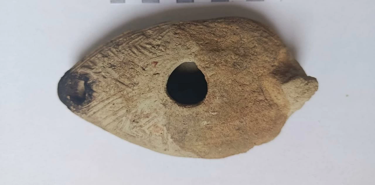
وتضمنت المكتشفات كميات من الفخار كبير الحجم، كان يستخدم في تخزين المياه والمؤن، إلى جانب أوانٍ ذات طلاء أخضر زيتوني، وأخرى باللونين الأحمر والأبيض، فضلاً عن أجزاء من مسارج كانت تستخدم في الإضاءة.
وأضاف أن قرب الموقع من محطات تاريخية أخرى، من بينها الخوينات وعمورية وقاطية، يضع «عسيلة» ضمن شبكة من المحطات والمنشآت التي ارتبطت بحركة التجارة والحج والتنقل في سيناء.
وأكد أن هذا الموقع يحظى بأهمية خاصة في دراسة تاريخ المنطقة، باعتبار سيناء جسرًا حضارياً وتجاريًا بين مصر والمشرق.
أدلة أثرية ترجح العصر المملوكي
وأوضح رئيسا البعثة الأثرية، محمد خليل وصدام حسين، أن الكشف يسهم في فهم طبيعة البنية التحتية التي دعمت حركة التجارة والحج والتحركات العسكرية خلال العصور الإسلامية، كما يساعد الكشف على دراسة شبكة المحطات الإستراتيجية التي أقيمت على طرق سيناء لخدمة المسافرين والقوافل.
وأشار رئيسا البعثة إلى أن اللقى الأثرية المكتشفة حتى الآن ترجح تأريخ الموقع إلى العصر المملوكي، ومن بينها أوانٍ ذات طلاء أخضر زيتوني مميزة لهذه الفترة.
كما عُثر على كسر من الفخار المزجج تحمل عناصر زخرفية يمكن نسبتها إلى فترة السلطان الناصر محمد بن قلاوون في العصر المملوكي البحري.
وتحمل بعض اللقى كذلك حروفًا عربية قد تكون جزءًا من كلمة «الناصر»، إلا أن تحديد دلالة هذه الكتابات وتأريخ الموقع بصورة أكثر دقة لا يزال يتطلب مزيداً من الدراسة والتحليل الأثري.
حفائر جديدة لتأكيد وظيفة الخان
وتواصل البعثة الأثرية أعمالها للكشف عن المزيد من التفاصيل المعمارية للمبنى وملحقاته، بما قد يسهم في تأكيد وظيفته باعتباره خان طريق، إلى جانب استكمال أعمال التوثيق والدراسة والترميم.
«درب الحاج المصري».. طريق تاريخي بين مصر والحجاز والشام
ويُعد الدرب السلطاني، المعروف أيضًا باسم «درب الحاج المصري»، أحد الطرق التاريخية المهمة التي استخدمت لخدمة حركة الحجاج المتجهين إلى مكة المكرمة، إلى جانب القوافل التجارية وحركة البريد والتنقل بين مصر وبلاد الشام وشبه الجزيرة العربية.
وتشير الدراسات التاريخية إلى أن الطريق ظل مستخدمًا لقرون، قبل أن تؤدي التطورات السياسية والعسكرية التي شهدتها المنطقة، ولا سيما الخطر الصليبي في الشرق خلال القرن الحادي عشر الميلادي، إلى توقف استخدامه وتحول مسار حركة الحج إلى الطريق الجنوبي عبر عيذاب–جدة.
ويضيف الكشف الجديد في «عسيلة» حلقة مهمة إلى سلسلة المواقع الأثرية المرتبطة بهذا الطريق التاريخي، بما يتيح للباحثين فرصة أوسع لفهم شبكة الطرق والمحطات التي أسهمت في تنظيم حركة الحجاج والتجار والمسافرين عبر سيناء على مدى قرون.
In an important and rare archaeological discovery, the mission of the Supreme Council of Antiquities, affiliated with the Egyptian Ministry of Tourism and Antiquities, succeeded in uncovering the remains of an ancient building in the lost city of Asilah in North Sinai. It is believed to have been one of the caravanserais that served commercial caravans and the Egyptian pilgrims traveling along the Sultan's Road, known as the "Egyptian Pilgrim's Path," which connected Egypt with the Arabian Peninsula and the Levant.
This discovery comes as part of the efforts of the Ministry of Tourism and Antiquities, represented by the Supreme Council of Antiquities, to uncover archaeological and cultural treasures across the country and shed more light on the history of Sinai, its cities, and its historical routes.
The Discovery Reinterprets the History of Sinai
For his part, the Egyptian Minister of Tourism and Antiquities, Sherif Fathy, described the discovery as an important addition to the series of archaeological discoveries that contribute to the reinterpretation of the history of Sinai and highlight the civilizations and communities that flourished on its land.
The minister explained that the site had remained buried under the sands for centuries before excavation work began last year, gradually revealing its features and reviving its history.
He added that the discovery of "Asilah" opens a new window onto the historical road network that connected Egypt with the Arab East, along with the associated movement of pilgrims, traders, armies, and mail.
Fathy confirmed that the Ministry of Tourism and Antiquities places great importance on excavation, documentation, and restoration work in Sinai, contributing to the preservation of its heritage and highlighting its historical and cultural significance.
Walls and Chambers Reveal the Building's Function
For his part, the Secretary-General of the Supreme Council of Antiquities, Dr. Hisham El-Leithy, stated that excavation work revealed the remains of walls constructed from mud bricks and red bricks, supported at their foundations by large limestone stones, which is an architectural style that was common in the construction and reinforcement of major facilities during the Islamic eras.
He pointed out that the discovered walls extend in the directions of north, east, and south, and include internal architectural formations indicating the presence of several chambers.
It is believed that some of these chambers may have been used as shops attached to the caravanserai, noting that the overall layout of the site closely resembles that of Khan Al-Khowainat, one of the important trading stations in North Sinai.
He explained that the site of "Asilah" is smaller in area than Khan Al-Khowainat, which supports the hypothesis of its use as a rest stop for pilgrims and traders on the Sultan's Road.
Pottery and Lamps Reveal Details of Daily Life
For his part, the head of the Islamic and Coptic Antiquities Sector, Dr. Diaa Zahran, stated that the excavation work resulted in the discovery of a collection of artifacts that reflect the nature of daily life at the site.
The discoveries included large quantities of pottery used for storing water and provisions, as well as vessels with olive green glaze, and others in red and white colors, in addition to parts of lamps that were used for lighting.
He added that the proximity of the site to other historical stations, including Al-Khowainat, Amouria, and Qatiya, places "Asilah" within a network of stations and facilities linked to trade, pilgrimage, and movement in Sinai.
He confirmed that this site holds special significance in studying the history of the region, considering Sinai as a cultural and commercial bridge between Egypt and the East.
Archaeological Evidence Suggests the Mamluk Era
The heads of the archaeological mission, Mohamed Khalil and Saddam Hussein, explained that the discovery contributes to understanding the nature of the infrastructure that supported trade, pilgrimage, and military movements during the Islamic eras, and helps study the network of strategic stations established along the roads of Sinai to serve travelers and caravans.
The heads of the mission noted that the artifacts discovered so far suggest dating the site to the Mamluk era, including vessels with distinctive olive green glaze from this period.
They also found fragments of glazed pottery bearing decorative elements that can be attributed to the period of Sultan Al-Nasir Muhammad bin Qalawun during the Mamluk naval era.
Some artifacts also bear Arabic letters that may be part of the word "Al-Nasir," but determining the significance of these inscriptions and dating the site more accurately still requires further study and archaeological analysis.
New Excavations to Confirm the Function of the Caravanserai
The archaeological mission continues its work to uncover more architectural details of the building and its annexes, which may help confirm its function as a caravanserai, in addition to completing documentation, study, and restoration work.
"The Egyptian Pilgrim's Path" - A Historical Route Between Egypt, Hijaz, and the Levant
The Sultan's Road, also known as "The Egyptian Pilgrim's Path," is one of the important historical routes used to serve the movement of pilgrims heading to Mecca, along with commercial caravans and the movement of mail and travel between Egypt, the Levant, and the Arabian Peninsula.
Historical studies indicate that the road remained in use for centuries before political and military developments in the region, particularly the Crusader threat in the East during the 11th century AD, led to its cessation and the redirection of pilgrimage movement to the southern route via Aydhab–Jeddah.
The new discovery in "Asilah" adds an important link to the series of archaeological sites associated with this historical road, providing researchers with a broader opportunity to understand the network of roads and stations that contributed to organizing the movement of pilgrims, traders, and travelers across Sinai over the centuries.