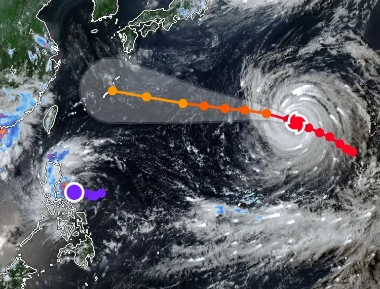
يواصل الإعصار المداري الشديد (دولفين) تحركه فوق مياه المحيط الهادئ متجهًا نحو السواحل الشرقية لقارة آسيا، وسط حالة تأهب واسعة في الدول الواقعة ضمن مساره المتوقع.
ووفقًا لآخر البيانات الصادرة عن الهيئات المناخية الرسمية، فقد شهد الإعصار تراجعًا طفيفًا في شدته بعد بلوغه ذروة القوة خلال الأيام الماضية كإعصار خارق، ليصنّف حاليًا كإعصار من الفئة الثالثة المتقدمة.
وترافق مركز الإعصار سرعات رياح تتراوح بين 200 و220 كيلومترًا في الساعة، بينما يتحرك باتجاه الشمال الغربي فوق المياه المفتوحة للمحيط الهادئ بالقرب من جزر أوجاساوارا اليابانية.
وقد أصدرت وكالة الأرصاد الجوية اليابانية تحذيرات مشددة لسكان الجزر الجنوبية والمناطق الساحلية من أمواج عاتية قد يتجاوز ارتفاعها عشرة أمتار، إضافة إلى أمطار غزيرة قد تتسبب في انهيارات أرضية وسيول جارفة خلال الأيام المقبلة مع اقتراب الإعصار من مجالات جزر أوكيناوا وأمامي.
وفي المقابل، رفعت السلطات الصينية والتايوانية مستوى الجاهزية لمواجهة التبعات غير المباشرة للإعصار، إذ يُتوقع تدفق كميات كبيرة من الرطوبة والغيوم الركامية نحو السواحل الشرقية، مما يهدد بارتفاع مناسيب المياه في أحواض الأنهار الرئيسية وحدوث فيضانات في المناطق المنخفضة.
وتواصل الأجهزة المعنية في تلك الدول حثّ المواطنين على الالتزام بتعليمات السلامة والابتعاد عن الشواطئ ومجاري السيول إلى حين زوال خطر الإعصار.
The severe tropical cyclone (Dolphin) continues to move over the waters of the Pacific Ocean, heading towards the eastern coasts of the Asian continent, amid widespread alertness in the countries located within its expected path.
According to the latest data released by official meteorological agencies, the cyclone has experienced a slight decrease in intensity after reaching peak strength in recent days as a super cyclone, and is currently classified as a Category 3 hurricane.
The center of the cyclone is accompanied by wind speeds ranging from 200 to 220 kilometers per hour, while it moves northwest over the open waters of the Pacific Ocean near the Japanese Ogasawara Islands.
The Japan Meteorological Agency has issued strict warnings to residents of the southern islands and coastal areas about towering waves that may exceed ten meters in height, in addition to heavy rains that could cause landslides and flash floods in the coming days as the cyclone approaches the Okinawa and Amami Islands.
In contrast, Chinese and Taiwanese authorities have raised the readiness level to face the indirect consequences of the cyclone, as large amounts of moisture and cumulonimbus clouds are expected to flow towards the eastern coasts, threatening to raise water levels in the main river basins and cause flooding in low-lying areas.
The relevant agencies in those countries continue to urge citizens to adhere to safety instructions and stay away from beaches and riverbeds until the threat of the cyclone has passed.