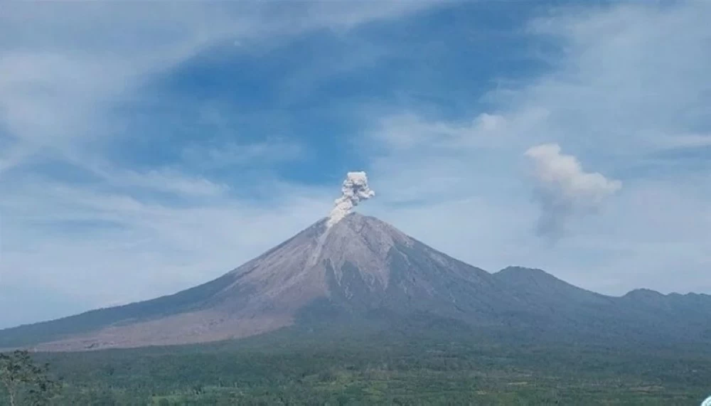
شهد جبل سيميرو في إقليم جاوا الشرقية بإندونيسيا، صباح اليوم (الأربعاء)، 6 ثورات بركانية متتالية، أطلقت أعمدة من الدخان والرماد راوحت ارتفاعاتها بين 700 و900 متر فوق القمة، وفق السلطات المحلية.
وذكرت وكالة الأنباء الإندونيسية «أنتارا» أن أول ثوران سُجّل عند الساعة 12:26 بعد منتصف الليل، تبعه عدة ثورات لاحقة، كانت أقواها عند الساعة 6:46 صباحاً، عندما بلغ عمود الرماد 900 متر، ونحو الشمال والشمال الشرقي اتجه عمود الرماد ذو كثافة عالية ولون بين الأبيض والرمادي، بحسب سيجيت ريان ألفيان المسؤول في مرصد جبل سيميرو.
وأوضحت السلطات الإندونيسية أن بداية الثورات البركانية سُجلت زلزالياً بسعة 16 مليمتراً لمدة 120 ثانية، بينما سُجّل ثوران آخر عند الساعة 9:37 صباحاً بسعة 22 مليمتراً لمدة 105 ثوانٍ، دون مشاهد بصرية مباشرة.
ويقع جبل سيميرو على ارتفاع 3676 متراً فوق سطح البحر، ولا يزال في مستوى التأهب الثالث، ما دفع مركز علم البراكين وإدارة المخاطر الجيولوجية إلى إصدار تحذيرات عاجلة للسكان.
وشددت التوصيات على:
- منع الأنشطة البشرية في القطاع الجنوبي الشرقي، خصوصاً على امتداد نهر بيسوك كوبوكان ضمن نطاق 13 كيلومتراً من القمة.
- حظر الاقتراب لمسافة 500 متر من ضفاف النهر، مع احتمالية امتداد التدفقات البركانية والحممية لمسافة تصل إلى 17 كيلومتراً.
- عدم الاقتراب ضمن دائرة نصف قطرها 5 كيلومترات من فوهة البركان، تحسباً لتساقط الصخور المنصهرة.
- توخي الحذر من التدفقات البركانية والسيلية في الأودية والأنهار المنحدرة، خصوصاً في مناطق بيسوك كوبوكان وبيسوك بانغ وبيسوك كيمبار وبيسوك سات.
وأكدت الجهات المعنية أنها تواصل مراقبة النشاط البركاني عن كثب، داعية السكان إلى الالتزام التام بالتعليمات حفاظاً على حياتهم.
Mount Semeru in East Java, Indonesia, witnessed 6 consecutive volcanic eruptions this morning (Wednesday), releasing columns of smoke and ash that reached heights between 700 and 900 meters above the summit, according to local authorities.
The Indonesian news agency "Antara" reported that the first eruption was recorded at 12:26 AM, followed by several subsequent eruptions, the strongest of which occurred at 6:46 AM, when the ash column reached 900 meters. The ash column, which was dense and colored between white and gray, drifted towards the north and northeast, according to Sigit Ryan Alfian, an official at the Semeru Volcano Observatory.
Indonesian authorities explained that the onset of the volcanic eruptions was recorded seismically with a magnitude of 16 millimeters for 120 seconds, while another eruption was recorded at 9:37 AM with a magnitude of 22 millimeters for 105 seconds, without any direct visual observations.
Mount Semeru stands at an elevation of 3,676 meters above sea level and remains at alert level three, prompting the Center for Volcanology and Geological Hazard Mitigation to issue urgent warnings to residents.
The recommendations emphasized:
- Prohibiting human activities in the southeastern sector, especially along the Besuk Kobokan River within a 13-kilometer radius from the summit.
- Banning approaches within 500 meters of the riverbanks, with the possibility of volcanic and hot flows extending up to 17 kilometers.
- Not approaching within a 5-kilometer radius of the volcano's crater, in anticipation of falling molten rocks.
- Exercising caution regarding volcanic and lahar flows in the valleys and descending rivers, especially in the areas of Besuk Kobokan, Besuk Pang, Besuk Kembar, and Besuk Sat.
Relevant authorities confirmed that they are closely monitoring volcanic activity and urged residents to fully comply with the instructions to ensure their safety.