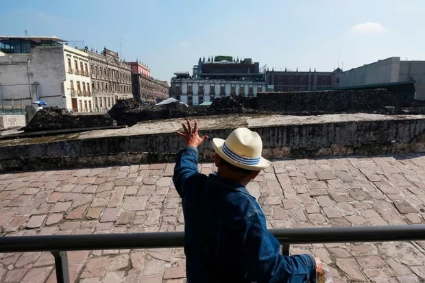
تكشف المباني المائلة والطرقات المتشققة في العاصمة المكسيكية مكسيكو سيتي عن أزمة بيئية متفاقمة تعيشها المدينة منذ أكثر من قرن، إذ تؤكد الدراسات الحديثة أن المدينة تغرق تدريجيًا بوتيرة تعد من الأسرع في العالم، بحسب صحيفة الغارديان.
وفي تطور علمي لافت، تمكن قمر صناعي متطور يحمل اسم «نيسار» (NISAR)، وهو مشروع مشترك بين وكالة الفضاء الأمريكية ناسا ومنظمة أبحاث الفضاء الهندية، من رصد معدلات الهبوط الأرضي في المدينة بدقة غير مسبوقة.
وبحسب البيانات الجديدة، فإن بعض مناطق العاصمة، بما في ذلك المطار الرئيسي، تهبط بأكثر من سنتيمترين شهريًا، وهو معدل يثير قلق العلماء والسلطات على حد سواء.
مدينة تميل حرفيًا
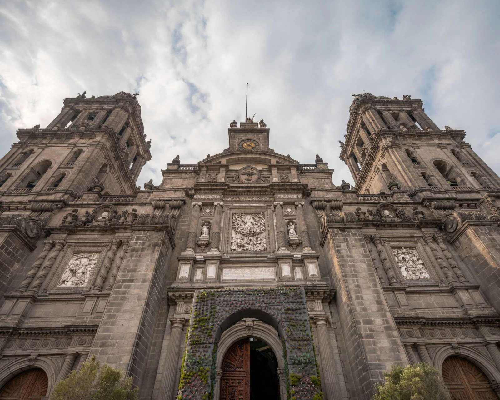
ويظهر تأثير الهبوط الأرضي بوضوح في ساحة زوكالو التاريخية وسط المدينة، حيث تبدو الكاتدرائية الرئيسية ومبانٍ تاريخية أخرى مائلة في اتجاهات مختلفة نتيجة الانخفاض التدريجي للتربة.
كما اضطر المسؤولون إلى إضافة 14 درجة جديدة إلى قاعدة نصب ملاك الاستقلال، أحد أشهر معالم العاصمة، منذ بنائه عام 1910، بسبب استمرار انخفاض مستوى الأرض المحيطة به.
ولا تقتصر الأضرار على المعالم التاريخية، إذ تشمل أيضًا الطرق، وشبكات المياه والصرف الصحي، وخطوط المترو، والبنية التحتية الحيوية التي تخدم نحو 22 مليون نسمة يعيشون في المدينة وضواحيها.
لماذا تغرق المدينة؟
ويرجع الخبراء السبب الرئيسي إلى الاستنزاف المفرط للمياه الجوفية.
فالعاصمة المكسيكية شُيّدت فوق بحيرة قديمة، ما يجعل التربة تحتها رخوة وغنية بالطين، ومع ضخ المياه من الطبقات الجوفية بوتيرة تفوق بكثير معدلات تجددها الطبيعي عبر الأمطار، تبدأ الأرض بالانضغاط تدريجيًا تحت وزن المدينة.
وأوضح علماء من وكالة ناسا أن استمرار سحب المياه يؤدي إلى تقلص الخزان الجوفي وانخفاض مستوى المياه بنحو 40 سنتيمترًا سنويًا.
حلقة مفرغة
ويؤدي هبوط الأرض إلى تشقق أنابيب المياه القديمة، ما يتسبب في فقدان نحو 40% من المياه بسبب التسرب، وفق تقديرات رسمية.
ومع تفاقم آثار التغير المناخي وتراجع معدلات الأمطار خلال السنوات الأخيرة، يخشى خبراء من أن تواجه أجزاء واسعة من المدينة أزمة مياه حادة قد تصل إلى جفاف الصنابير بالكامل.
تقنية فضائية ترصد الكارثة
ويتميز نظام «نيسار» بقدرته على رصد التغيرات الدقيقة جدًا في سطح الأرض حتى عبر الغيوم أو الغطاء النباتي الكثيف، ما يمنح العلماء صورة أوضح لتطور الظاهرة عبر الزمن.
وأكد باحثون أن التقنية الجديدة لن تقتصر فوائدها على مراقبة المدن الغارقة، بل ستساعد أيضًا في دراسة الزلازل والبراكين والانهيارات الأرضية والتغيرات المناخية حول العالم.
ورغم أن الصور الفضائية الجديدة قد تسهم في زيادة الوعي بحجم الأزمة، فإن الخبراء يؤكدون أن وقف هبوط المدينة يبدو مهمة شديدة التعقيد.
وقال المهندس المكسيكي إيفراين أوفاندو شيللي: «لإيقاف الهبوط علينا وقف استخراج المياه الجوفية، لكن إذا توقفنا عن استخراج المياه، فمن أين سنشرب؟».
وأضاف ساخرًا: «النكتة المتداولة هنا تقول: إذا لم نجد ماءً للشرب، فسنشرب التكيلا».
The leaning buildings and cracked roads in Mexico City reveal an escalating environmental crisis that the city has been experiencing for over a century. Recent studies confirm that the city is gradually sinking at one of the fastest rates in the world, according to The Guardian.
In a remarkable scientific development, an advanced satellite named "NISAR," a joint project between NASA and the Indian Space Research Organisation, has been able to accurately monitor land subsidence rates in the city with unprecedented precision.
According to new data, some areas of the capital, including the main airport, are sinking by more than two centimeters per month, a rate that raises concerns among both scientists and authorities.
A City Literally Sinking
The impact of land subsidence is clearly visible in the historic Zócalo Square in the city center, where the main cathedral and other historical buildings appear to be leaning in different directions due to the gradual lowering of the ground.
Officials have also been forced to add 14 new steps to the base of the Angel of Independence monument, one of the capital's most famous landmarks, since its construction in 1910, due to the ongoing decline of the surrounding ground level.
The damage is not limited to historical landmarks; it also includes roads, water and sewage networks, metro lines, and vital infrastructure serving around 22 million people living in the city and its suburbs.
Why is the City Sinking?
Experts attribute the main cause to the excessive depletion of groundwater.
The Mexican capital was built on an ancient lake, making the soil beneath it soft and rich in clay. With water being pumped from the aquifers at a rate that far exceeds its natural replenishment through rainfall, the ground begins to gradually compress under the weight of the city.
Scientists from NASA explained that the continued extraction of water leads to the shrinking of the aquifer and a decrease in water levels by about 40 centimeters annually.
A Vicious Cycle
Land subsidence causes old water pipes to crack, resulting in the loss of about 40% of water due to leaks, according to official estimates.
As the effects of climate change worsen and rainfall rates decline in recent years, experts fear that large parts of the city may face a severe water crisis that could lead to complete tap water shortages.
Space Technology Monitoring the Disaster
The NISAR system is distinguished by its ability to detect very subtle changes in the Earth's surface even through clouds or dense vegetation, providing scientists with a clearer picture of the phenomenon's evolution over time.
Researchers confirmed that the new technology will not only benefit the monitoring of sinking cities but will also aid in the study of earthquakes, volcanoes, landslides, and climate changes around the world.
Although the new satellite images may help raise awareness of the scale of the crisis, experts assert that stopping the city's sinking appears to be a highly complex task.
Mexican engineer Iván Ofrando Shelley said, "To stop the sinking, we need to stop extracting groundwater, but if we stop extracting water, where will we drink from?"
He added sarcastically, "The joke going around here says: If we can't find water to drink, we'll drink tequila."