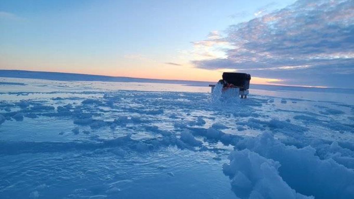
شهد القطب الشمالي تراجعا ملحوظا في مساحة الجليد البحري خلال شهر سبتمبر، إذ وصل الحد الأدنى السنوي إلى 4.60 مليون كيلومتر مربع (1.78 مليون ميل مربع) يوم 10 سبتمبر، وفقا لمركز بيانات الجليد والثلج الوطني التابع لناسا.
ويحتل هذا الرقم المرتبة العاشرة ضمن أدنى المساحات المسجلة منذ بدء المراقبة بالأقمار الصناعية عام 1979، متساويا مع مستويات عامي 2008 و2010، ومع أنه ليس رقما قياسيا، إلا أنه يعزز الاتجاه الطويل الأمد للذوبان، إذ سجلت الـ19 عاما الأخيرة أدنى مستويات الجليد في السجل التاريخي، مما يثير مخاوف من اقتراب عصر «القطب الشمالي الخالي من الجليد» في الصيف قبل منتصف القرن الحالي.
تقلص الجليد الشمالي
وأفاد الدكتور والتون ميير، عالم الجليد في مركز بيانات الجليد والثلج الوطني التابع لوكالة ناسا، أن «الحد الأدنى في 2025 يستمر في الاتجاه السائد منذ عقود، إذ يتقلص الجليد الشمالي بمعدل 12.1% كل عقد مقارنة بالمتوسط للفترة 1981-2010»، مشيرا إلى أن فقدان الجليد يعادل خسارة مساحة بحجم ولاية ساوث داكوتا أو دولة النمسا سنويا، أي نحو 74 ألف كيلومتر مربع كل عام.
القطب الشمالي وتحذير ناسا.
ومع ذلك، لم يرصد الخبراء انخفاضا كبيرا في السنوات الأخيرة، إذ يبدو المنحنى مستقرا نسبيا منذ 2007، لكن هذا الاستقرار لا ينفي الاتجاه العام للتراجع بسبب الاحتباس الحراري.
وبدأت مراقبة الجليد الشمالي بالأقمار الصناعية في عام 1979، عندما كان الحد الأدنى السنوي يتجاوز 7 ملايين كيلومتر مربع في المتوسط.
تسارع الذوبان
ومع مرور السنوات، أدى الاحتباس الحراري الناتج عن غازات الدفيئة إلى تسارع الذوبان، إذ ارتفعت درجات الحرارة في القطب الشمالي بمعدل أسرع من أي مكان آخر على الأرض -ما يُعرف بـ«التعزيز القطبي».
وفي عام 2012، سجل الرقم القياسي الأدنى عند 3.39 مليون كيلومتر مربع، تلاه 2020 بـ3.74 مليون، وفقا لبيانات مركز بيانات الجليد والثلج الوطني، وفي 2025، وصل الجليد إلى الحد الأدنى أربعة أيام أبكر من المتوسط التاريخي (14 سبتمبر)، مما يشير إلى موسم ذوبان أسرع بسبب درجات حرارة أعلى في الصيف.
جليد بالقطب الشمالي.
تحذيرات ناسا
وأظهرت الصور عبر القمر الصناعي بقعا كبيرة من الجليد الرقيق في بحر سيبيريا وغرينلاند، مع مناطق مفتوحة من المحيط المتجمد الشمالي، ووفقا لتقرير ناسا، فإن فقدان الجليد يؤثر على المناخ العالمي بشكل مباشر: الجليد الأبيض يعكس أشعة الشمس، بينما المياه المكشوفة الداكنة تمتص الحرارة، مما يسرع الاحترار ويغير أنماط الطقس، مثل زيادة العواصف الشديدة في أوروبا وأمريكا الشمالية.
وعلى الرغم من عدم تسجيل انخفاض كبير في 2025 مقارنة بالسنوات السابقة، إلا أن العلماء يحذرون من أن الجليد متعدد السنوات (السميك) قد وصل إلى أدنى مستوياته التاريخية، مما يجعل التعافي أصعب، إذ يتوقع خبراء مثل أولئك في منظمة مونغاباي أن يصبح القطب الشمالي خاليا من الجليد في الصيف قبل 2050، وربما في الثلاثينيات، مما يهدد التنوع البيولوجي (مثل الدببة القطبية) والشعوب الأصلية التي تعتمد على الجليد للصيد والتنقل.
The Arctic has witnessed a significant decline in sea ice extent during September, with the annual minimum reaching 4.60 million square kilometers (1.78 million square miles) on September 10, according to NASA's National Snow and Ice Data Center.
This figure ranks tenth among the lowest extents recorded since satellite monitoring began in 1979, equaling levels from 2008 and 2010. Although it is not a record, it reinforces the long-term trend of melting, as the last 19 years have recorded the lowest ice levels in the historical record, raising concerns about the approach of a "summer ice-free Arctic" before the middle of this century.
Decline of Arctic Ice
Dr. Walt Meier, a snow and ice scientist at NASA's National Snow and Ice Data Center, reported that "the minimum in 2025 continues the trend that has been ongoing for decades, with Arctic ice shrinking at a rate of 12.1% per decade compared to the average for the period 1981-2010," noting that the loss of ice is equivalent to losing an area the size of South Dakota or Austria each year, roughly 74,000 square kilometers annually.
القطب الشمالي وتحذير ناسا.
However, experts have not observed a significant decline in recent years, as the curve appears relatively stable since 2007, but this stability does not negate the overall trend of decline due to global warming.
Satellite monitoring of Arctic ice began in 1979, when the annual minimum averaged over 7 million square kilometers.
Accelerating Melting
Over the years, global warming caused by greenhouse gases has accelerated melting, with temperatures in the Arctic rising faster than anywhere else on Earth—what is known as "Arctic amplification."
In 2012, the record low was set at 3.39 million square kilometers, followed by 2020 with 3.74 million, according to data from the National Snow and Ice Data Center. In 2025, the ice reached its minimum four days earlier than the historical average (September 14), indicating a faster melting season due to higher summer temperatures.
جليد بالقطب الشمالي.
NASA Warnings
Satellite images have shown large patches of thin ice in the Siberian Sea and Greenland, with open areas of the Arctic Ocean. According to NASA's report, the loss of ice directly affects the global climate: white ice reflects sunlight, while dark open water absorbs heat, accelerating warming and altering weather patterns, such as increasing severe storms in Europe and North America.
Although no significant decline was recorded in 2025 compared to previous years, scientists warn that multi-year (thick) ice has reached its historical lows, making recovery more difficult. Experts like those at Mongabay predict that the Arctic could be ice-free in summer before 2050, possibly in the 2030s, threatening biodiversity (such as polar bears) and indigenous peoples who rely on ice for hunting and transportation.