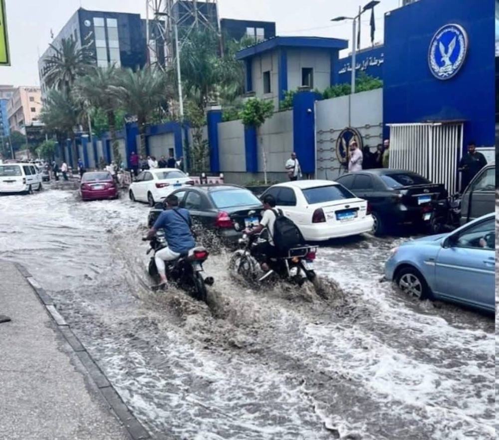
فاجأت موجة أمطار رعدية غزيرة عدة محافظات مصرية، بما في ذلك القاهرة الكبرى، والدقهلية، والإسماعيلية، وبورسعيد، رغم الطقس شديد الحرارة والرطوبة العالية التي تشهدها البلاد. وأصدرت الهيئة العامة للأرصاد الجوية بيانا عاجلا اليوم الثلاثاء، كشفت فيه عن أسباب هذه الظاهرة النادرة، التي وصفتها بأنها «غير موسمية» ولم تشهدها مصر بهذا الحجم منذ ثلاثة عقود.
وأوضح الدكتور محمود القياتي، عضو المركز الإعلامي بهيئة الأرصاد، أن صور الأقمار الصناعية رصدت مرور منخفض جوي سريع في طبقات الجو العليا، تسبب في تكاثر السحب المنخفضة والمتوسطة وتطورها بشكل متسارع، ما أدى إلى هطول أمطار رعدية متفاوتة الشدة، خاصة في جنوب وشرق القاهرة الكبرى. وأشار إلى أن الكتلة الممطرة تحركت تدريجيا شرقا نحو مدن القناة، لكن بشدة أقل. وأكد أن هذه الظاهرة نادرة الحدوث في يوليو، حيث أصدرت الهيئة تحذيرات فورية للمواطنين بتجنب المناطق المنخفضة واتخاذ الحيطة أثناء القيادة، مضيفا أن الرطوبة العالية، التي بلغت 85% في القاهرة، مرتبطة بسيطرة منخفض الهند الموسمي، الذي يجلب كتلا هوائية رطبة من البحر المتوسط، ما يزيد من الإحساس بالحرارة التي تجاوزت 40 درجة مئوية محسوسة في القاهرة الكبرى والوجه البحري. وأفادت تقارير إضافية من الهيئة أن الأمطار تسببت في تراكم مياه في شوارع القاهرة، خاصة في مدينة نصر والتجمع الخامس، ما أدى إلى إغلاق مؤقت لبعض الطرق الرئيسية، بينما تعاملت فرق الحماية المدنية مع حالات طفيفة للغرق في المناطق المنخفضة.
وأثارت الأمطار الصيفية المفاجئة حالة من الدهشة والجدل على منصات التواصل الاجتماعي، حيث نشر مستخدمون على «X» مقاطع فيديو تُظهر الرياح القوية وتساقط الأمطار مصحوبة بالغبار، مع تعليقات مثل «الصيف بقى شتاء في يوم واحد!» و«القاهرة تحت المطر في عز الحر!»، كما تزامن الحدث مع تحذيرات سابقة من قبطان بحري حول حركة أمواج غير عادية في البحر المتوسط، ما أثار مخاوف من ظواهر مناخية غير متوقعة، لكن الهيئة نفت وجود أي ارتباط بين الأمطار والنشاط الزلزالي. ووفقا لمصادر محلية، تسببت الأمطار في تعطيل حركة المرور في القاهرة الكبرى لمدة تصل إلى ساعتين في مناطق مثل طريق السويس ومحور المشير طنطاوي، حيث اضطرت السلطات إلى نشر فرق صيانة لتصريف المياه، كما أفادت تقارير من مدن القناة بتساقط أمطار خفيفة إلى متوسطة، مع رياح مثيرة للأتربة في الإسماعيلية وبورسعيد. وأعلنت محافظة القاهرة حالة الطوارئ المؤقتة للتعامل مع تجمعات المياه، مع تخصيص خط ساخن لتلقي شكاوى المواطنين. وأشارت الهيئة إلى أن الأمطار قد تستمر بشكل متقطع حتى الأربعاء، مع تحسن تدريجي في الأحوال الجوية بحلول الخميس 3 يوليو 2025. وتأتي هذه الأمطار في سياق ظواهر مناخية متطرفة تشهدها المنطقة، حيث سجل البحر المتوسط في يونيو أعلى درجة حرارة سطحية بمتوسط 26.01 درجة مئوية، وفقا لبرنامج كوبرنيكوس الأوروبي، وقد شهدت دول مجاورة ظواهر مشابهة، مثل هطول أمطار غزيرة في السعودية في يونيو 2025، وانحسار مياه في سواحل لبنان عام 2023 بسبب تغيرات الضغط الجوي.
A wave of heavy thunderstorm rains surprised several Egyptian governorates, including Greater Cairo, Dakahlia, Ismailia, and Port Said, despite the extreme heat and high humidity the country is experiencing. The Egyptian Meteorological Authority issued an urgent statement today, Tuesday, revealing the reasons behind this rare phenomenon, which it described as "out of season" and has not been witnessed in Egypt at this scale for three decades.
Dr. Mahmoud Al-Qiati, a member of the media center at the Meteorological Authority, explained that satellite images detected the passage of a fast-moving low-pressure system in the upper atmosphere, which caused the rapid development of low and medium clouds, leading to varying intensities of thunderstorm rains, especially in the southern and eastern parts of Greater Cairo. He noted that the rain-bearing mass gradually moved eastward towards the canal cities, but with less intensity. He confirmed that this phenomenon is rare in July, as the authority issued immediate warnings to citizens to avoid low-lying areas and exercise caution while driving, adding that the high humidity, which reached 85% in Cairo, is linked to the dominance of the Indian monsoon low, which brings moist air masses from the Mediterranean Sea, increasing the sensation of heat that exceeded 40 degrees Celsius felt in Greater Cairo and the Nile Delta. Additional reports from the authority indicated that the rains caused water accumulation in the streets of Cairo, especially in Nasr City and the Fifth Settlement, leading to temporary closures of some main roads, while civil protection teams dealt with minor flooding incidents in low-lying areas.
The sudden summer rains sparked astonishment and debate on social media platforms, where users on "X" shared videos showing strong winds and rain accompanied by dust, with comments like "Summer has turned into winter in one day!" and "Cairo is under rain in the midst of heat!" The event coincided with previous warnings from a maritime captain about unusual wave movements in the Mediterranean Sea, raising concerns about unexpected climatic phenomena, but the authority denied any connection between the rains and seismic activity. According to local sources, the rains disrupted traffic in Greater Cairo for up to two hours in areas such as the Suez Road and the Mashir Tantawi Axis, prompting authorities to deploy maintenance teams for water drainage. Reports from the canal cities indicated light to moderate rains, with dust-raising winds in Ismailia and Port Said. The Cairo Governorate declared a temporary state of emergency to deal with water accumulations, with a hotline established to receive citizens' complaints. The authority indicated that the rains might continue intermittently until Wednesday, with gradual improvement in weather conditions expected by Thursday, July 3, 2025. These rains come in the context of extreme climatic phenomena being experienced in the region, as the Mediterranean Sea recorded its highest sea surface temperature in June at an average of 26.01 degrees Celsius, according to the European Copernicus program. Neighboring countries have witnessed similar phenomena, such as heavy rains in Saudi Arabia in June 2025 and water receding along the Lebanese coast in 2023 due to atmospheric pressure changes.