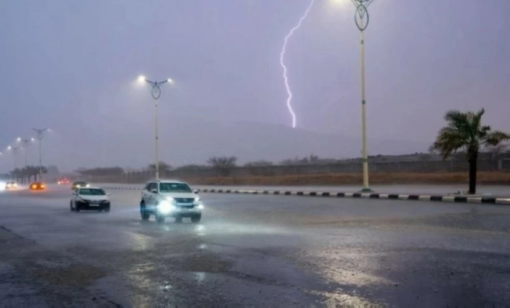
رفع المركز الوطني للأرصاد درجة التنبيه، معلناً دخول المملكة في موجة شتوية ثانية وصفها بالقوة والشمولية، تقترن فيها الأمطار الرعدية الغزيرة مع الرياح النشطة لتشكل حالة جوية تستمر حتى الخميس القادم، مستهدفة مناطق واسعة، أبرزها: الحدود الشمالية، الجوف، تبوك، والمدينة المنورة.
وأوضح المتحدث باسم المركز حسين القحطاني أن المملكة تشهد فعلياً الجولة الثانية من التقلبات الجوية لهذا الشهر، بالتزامن مع البداية الأرصادية لفصل الشتاء، إذ تتفاوت حدة الحالة بين المتوسطة والغزيرة لتغطي معظم مناطق المملكة باستثناء منطقة نجران.
وبيَّن القحطاني أن خرائط الرصد الجوي تتجه نحو المناطق الشمالية التي ستحظى بالنصيب الأكبر من الهطولات المطرية، ليمتد الحزام المطري الغزير مروراً بمحافظتي الوجه وأملج الساحليتين، وصولاً إلى منطقة المدينة المنورة التي ستكون تحت تأثير مباشر وواضح لهذه الاضطرابات.
شهر مطير
وأكد القحطاني أن شهر ديسمبر الجاري يُصنف كأول أشهر الشتاء الأرصادية، ومن المتوقع أن يكون شهراً «مطيراً» بامتياز، مسجلاً معدلات هطول تلامس المعدل الطبيعي أو قد تتجاوزه في بعض الفترات الزمنية.
وتشير التوقعات المناخية للمركز الوطني للأرصاد إلى أن درجات الحرارة ستبدأ رحلة انخفاض ملموس بحلول منتصف الشهر أو نهايته، وتحديداً خلال ساعات المساء، إذ ستبدأ الكتل الهوائية الباردة باجتياح المناطق الشمالية أولاً، ثم تزحف تدريجياً نحو الشرقية والمنطقة الوسطى (الرياض)، وصولاً إلى المناطق الجنوبية الداخلية.
وفي ذات الوقت، تحافظ السواحل الغربية والجنوبية للمملكة على هوامش اعتدال مناخي نسبي خلال الفصل البارد، بينما تظل المناطق الداخلية والمرتفعات عرضة لتقلبات حرارية أكثر حدة تتطلب جاهزية واستعداداً مبكراً من السكان.
The National Center of Meteorology has raised the alert level, announcing that the Kingdom is entering a second winter wave described as strong and comprehensive, where heavy thunderstorms are coupled with active winds to create a weather condition that will last until next Thursday, targeting wide areas, notably: the Northern Borders, Al-Jawf, Tabuk, and Medina.
The spokesperson for the center, Hussein Al-Qahtani, explained that the Kingdom is currently experiencing the second round of weather fluctuations for this month, coinciding with the meteorological start of winter, as the intensity of the condition varies between moderate and heavy, covering most regions of the Kingdom except for the Najran area.
Al-Qahtani indicated that the weather observation maps are directing towards the northern regions, which will receive the largest share of rainfall, with the heavy rain belt extending through the coastal governorates of Al-Wajh and Umluj, reaching the Medina area, which will be under direct and clear influence of these disturbances.
Rainy Month
Al-Qahtani confirmed that the current month of December is classified as the first month of meteorological winter, and it is expected to be an "exceptionally rainy" month, recording rainfall rates that touch or may exceed the normal average during certain time periods.
Climate forecasts from the National Center of Meteorology indicate that temperatures will begin a noticeable decline by mid or late month, specifically during the evening hours, as cold air masses start to sweep through the northern regions first, then gradually move towards the eastern and central areas (Riyadh), reaching the southern interior regions.
At the same time, the western and southern coasts of the Kingdom maintain a relatively moderate climatic margin during the cold season, while the interior and highland areas remain exposed to more severe thermal fluctuations, requiring early readiness and preparation from the residents.