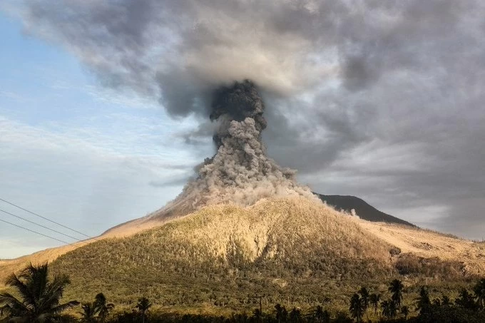
شهدت إندونيسيا، أمس (الأحد)، نشاطاً بركانياً مكثفاً بعد ثوران اثنين من أكثر براكينها نشاطاً، هما جبل «سيميرو» في جزيرة جاوة الشرقية، وجبل «ليفوتوبي لاكي-لاكي» في مقاطعة نوسا تينجارا الشرقية، مطلقين أعمدة كثيفة من الرماد البركاني ارتفعت إلى نحو كيلومتر فوق قمتيهما.
وذكرت الوكالة الجيولوجية الإندونيسية أن بركان «سيميرو» ثار خمس مرات خلال اليوم، وكان آخرها في الساعة 12:16 ظهراً بالتوقيت المحلي، إذ قذف عموداً من الرماد البركاني بلغ ارتفاعه نحو ألف متر فوق القمة.
وأوضح مراقب البراكين موكداس صوفيان أن عمود الرماد اتخذ اللونين الأبيض والرمادي بكثافة عالية، واتجه نحو الجنوب الغربي، مشيراً إلى أن الثوران استمر لنحو 130 ثانية، فيما سُجلت ثورانات أخرى في أوقات متفرقة من اليوم.
وفي الوقت نفسه، سجل بركان «ليفوتوبي لاكي-لاكي» ستة ثورانات متتالية، كان أعنفها في الساعة 10:16 صباحاً بالتوقيت المحلي، إذ اندفع الرماد البركاني إلى ارتفاع بلغ نحو 900 متر فوق القمة.
وقال مراقب البراكين برامانتيا أجي بوترا ماهيندرا إن عمود الرماد كان كثيفاً ورمادي اللون، وانجرف باتجاه الشمال والشمال الشرقي، بينما استمر الثوران قرابة 149 ثانية.
وأضاف أن البركان شهد عدة ثورانات أخرى راوحت فيها أعمدة الرماد بين 300 و500 متر، في حين حالت الظروف الجوية دون رصد سحب الرماد في ثورانين آخرين.
ولم تشر السلطات الإندونيسية حتى الآن إلى وقوع خسائر بشرية أو أضرار مادية جراء هذه الثورانات، فيما تواصل أجهزة الرصد الجيولوجي مراقبة النشاط البركاني عن كثب تحسباً لأي تصعيد جديد، خصوصاً أن البركانين يعدان من أكثر البراكين نشاطاً في الأرخبيل الإندونيسي.
وتقع إندونيسيا على ما يعرف بـ«حزام النار» في المحيط الهادئ، وهو أكثر المناطق نشاطاً زلزالياً وبركانياً في العالم، ويضم نحو 130 بركاناً نشطاً، ما يجعل البلاد من أكثر الدول تعرضاً للثورانات البركانية والزلازل.
ويُعد جبل «سيميرو»، الذي يبلغ ارتفاعه نحو 3676 متراً، أعلى قمة في جزيرة جاوة، ويشهد ثورانات متكررة على مدار السنوات الأخيرة. وفي ديسمبر 2021 تسبب ثورانه في مقتل العشرات وإصابة العشرات الآخرين، كما أدى إلى نزوح آلاف السكان وتدمير قرى وبنى تحتية بفعل تدفقات الحمم والرماد البركاني.
أما بركان «ليفوتوبي لاكي-لاكي»، الواقع في جزيرة فلوريس، فقد عاد إلى النشاط بشكل ملحوظ خلال العامين الماضيين، وشهد عدة ثورانات قوية دفعت السلطات إلى رفع مستوى التأهب وإجلاء السكان من المناطق المحيطة. كما تسببت بعض ثوراناته في اضطراب حركة الطيران نتيجة انتشار سحب الرماد البركاني في الأجواء.
ويؤكد خبراء الجيولوجيا أن الثورانات البركانية في إندونيسيا تمثل تحدياً دائماً للسلطات، التي تعتمد على شبكة واسعة من محطات الرصد والإنذار المبكر، بهدف تقليل المخاطر على السكان وحماية حركة الطيران والمرافق الحيوية، خصوصاً مع استمرار النشاط التكتوني في منطقة حزام النار.
Indonesia witnessed intense volcanic activity yesterday (Sunday) after the eruption of two of its most active volcanoes, Mount Semeru in East Java and Mount Lewotobi Lucky-Lucky in East Nusa Tenggara, releasing thick columns of volcanic ash that rose to about a kilometer above their summits.
The Indonesian Geological Agency reported that Mount Semeru erupted five times throughout the day, with the last eruption occurring at 12:16 PM local time, when it expelled a column of volcanic ash reaching about one thousand meters above the summit.
Volcano observer Mukdas Sofyan explained that the ash column exhibited both white and gray colors with high density, drifting towards the southwest, noting that the eruption lasted for about 130 seconds, while other eruptions were recorded at various times throughout the day.
Meanwhile, Mount Lewotobi Lucky-Lucky recorded six consecutive eruptions, the most violent of which occurred at 10:16 AM local time, when volcanic ash surged to a height of about 900 meters above the summit.
Volcano observer Bramantia Aji Putra Mahendra stated that the ash column was dense and gray, drifting towards the north and northeast, while the eruption lasted approximately 149 seconds.
He added that the volcano experienced several other eruptions where the ash columns ranged between 300 and 500 meters, while weather conditions prevented the observation of ash clouds during two other eruptions.
Indonesian authorities have not yet reported any casualties or material damage resulting from these eruptions, while geological monitoring agencies continue to closely observe volcanic activity in anticipation of any new escalation, especially since both volcanoes are among the most active in the Indonesian archipelago.
Indonesia is located on what is known as the "Ring of Fire" in the Pacific Ocean, which is the most seismically and volcanically active region in the world, containing about 130 active volcanoes, making the country one of the most prone to volcanic eruptions and earthquakes.
Mount Semeru, which stands at about 3,676 meters, is the highest peak on the island of Java and has experienced repeated eruptions over recent years. In December 2021, its eruption resulted in the deaths of dozens and injuries to many others, as well as the displacement of thousands of residents and the destruction of villages and infrastructure due to lava flows and volcanic ash.
On the other hand, Mount Lewotobi Lucky-Lucky, located on Flores Island, has noticeably returned to activity over the past two years, experiencing several strong eruptions that prompted authorities to raise the alert level and evacuate residents from surrounding areas. Some of its eruptions have also disrupted air traffic due to the spread of volcanic ash clouds in the atmosphere.
Geology experts confirm that volcanic eruptions in Indonesia pose a constant challenge for authorities, who rely on a wide network of monitoring and early warning stations to reduce risks to the population and protect air traffic and vital facilities, especially with ongoing tectonic activity in the Ring of Fire region.