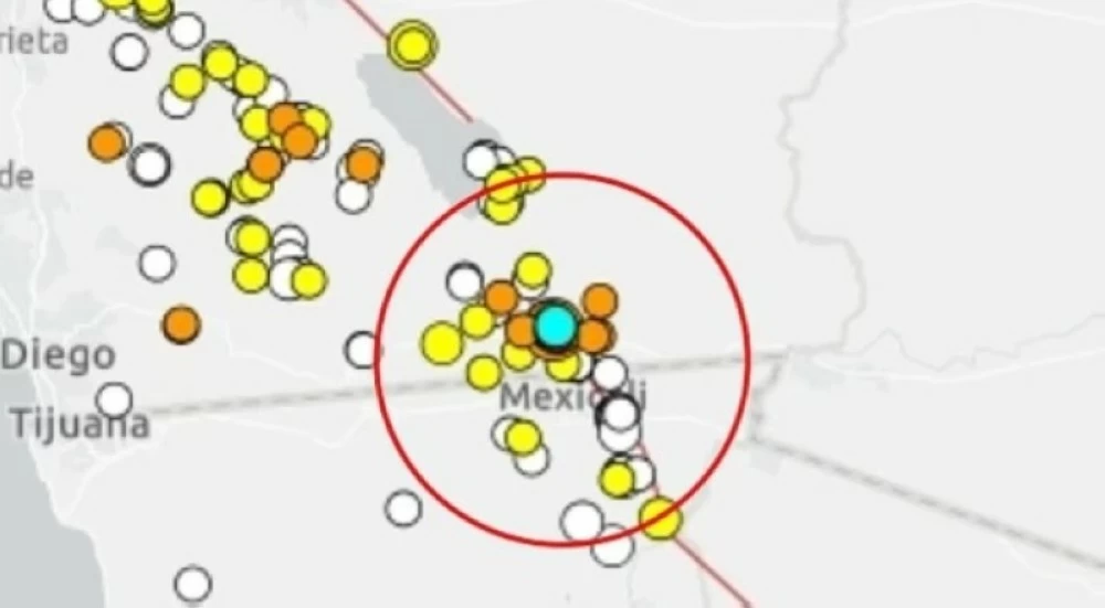
شهدت مناطق واسعة من جنوب ولاية كاليفورنيا سلسلة هزات أرضية متتالية خلال اليومين الماضيين، بلغ عددها نحو 40 زلزالًا، كان أقواها بقوة 4.4 درجة على مقياس ريختر، وفق هيئة المسح الجيولوجي الأمريكية.
وسُجل أول زلزال قرب بلدة هولتفيل في مقاطعة إمبريال عند الساعة 1:40 فجر الأربعاء بتوقيت المحيط الهادئ، فيما استمرت الهزات حتى صباح أمس (الخميس)، مع تفاوت واضح في شدتها.
وأفاد مئات السكان في كاليفورنيا بشعورهم بالاهتزازات، كما رُصدت موجات ارتدادية وصلت إلى أريزونا وشمال المكسيك، ما يعكس اتساع نطاق النشاط الزلزالي.
قوة متفاوتة
وتراوحت قوة الزلازل بين 1.1 و4.4 درجة، حيث تمر الهزات الأضعف غالبًا دون أن يشعر بها السكان.
ووفقًا لجامعة ميشيغان التقنية، فإن الزلازل التي تقل قوتها عن 2.5 نادرًا ما تُحَس، بينما يمكن للهزات بين 2.5 و5.4 درجة أن تُشعَر بها وقد تتسبب أحيانًا بأضرار طفيفة.
هل تمثل الهزات خطرًا أكبر؟
وعلى الرغم من أن أسراب الزلازل بهذا الحجم تُعد عادة غير خطيرة، يحذّر خبراء الزلازل من أنها قد تكون مؤشرًا على تحركات ضغط تكتوني على امتداد صدوع رئيسية، ما قد يمهد لزلزال أقوى في المستقبل.
وتقع هولتفيل، التي تبعد نحو 130 ميلًا شرق سان دييغو ويقطنها نحو 6,500 نسمة، في واحدة من أكثر المناطق نشاطًا زلزاليًا في الولاية، ضمن ما يُعرف بـ«حوض سالتون (Salton Trough)».
منطقة جيولوجية شديدة الحساسية
ويُعد حوض سالتون واديًا صدعيًا نشطًا يتمدد ببطء، حيث تتعرض القشرة الأرضية فيه لعمليات شد وتصدع مستمرة نتيجة حركة الصفائح التكتونية.
وتنتج هذه العمليات زلازل متكررة صغيرة إلى متوسطة، غالبًا ما تأتي في شكل أسراب بدلًا من زلزال منفرد.
ويقع مركز النشاط الزلزالي في منطقة معقدة من الصدوع المرتبطة بـ«صدع سان أندرياس الشهير»، الذي حذّر العلماء مرارًا من احتمالية حدوث زلزال مدمر عليه قد تتجاوز قوته 7.9 درجة.
سجل تاريخي مقلق
وللمنطقة تاريخ طويل مع الزلازل القوية، إذ شهدت مقاطعة إمبريال زلزالًا عنيفًا بقوة 6.9 درجة عام 1940، ألحق أضرارًا واسعة، كما وقع زلزال آخر بقوة 6.4 درجة عام 1979، شعر به سكان معظم جنوب كاليفورنيا وأسهم لاحقًا في تطوير معايير هندسة مقاومة الزلازل وأنظمة الإنذار المبكر.
لماذا تحدث أسراب زلزالية؟
ويوضح الجيولوجيون أن حوض سالتون يُعد جزءًا من منطقة صدع باخا كاليفورنيا، التي تربط نظام سان أندرياس في الشمال بمناطق التمدد في خليج كاليفورنيا جنوبًا.
ومع تحرك صفيحة المحيط الهادئ باتجاه الشمال الغربي مقابل الصفيحة الأمريكية الشمالية، تتعرض القشرة الأرضية للتمدد والترقق، ما يؤدي إلى تشققها على طول صدوع متعددة.
ولهذا السبب، تتوزع الطاقة الزلزالية على عدة صدوع بدلًا من تحررها دفعة واحدة، فتحدث هزات متتابعة قد تستمر لساعات أو أيام، وأحيانًا لأسابيع.
ورغم أن معظم هذه الهزات تبقى محدودة التأثير، يؤكد العلماء أن القوى التكتونية ذاتها قادرة، في ظروف معينة، على توليد زلازل أكبر وأكثر تدميرًا، خاصة على الصدوع المتصلة بسان أندرياس.
Wide areas of Southern California have experienced a series of consecutive earthquakes over the past two days, totaling around 40 quakes, the strongest of which registered a magnitude of 4.4 on the Richter scale, according to the U.S. Geological Survey.
The first earthquake was recorded near the town of Holtville in Imperial County at 1:40 AM Pacific Time on Wednesday, with tremors continuing until yesterday morning (Thursday), showing a noticeable variation in intensity.
Hundreds of residents in California reported feeling the tremors, and aftershocks were detected as far away as Arizona and northern Mexico, reflecting the widespread nature of the seismic activity.
Variable Strength
The strength of the earthquakes ranged from 1.1 to 4.4, with the weaker tremors often going unnoticed by residents.
According to Michigan Technological University, earthquakes with a magnitude of less than 2.5 are rarely felt, while tremors between 2.5 and 5.4 can be felt and may sometimes cause minor damage.
Do the Tremors Pose a Greater Risk?
Although swarms of earthquakes of this magnitude are generally considered non-threatening, earthquake experts warn that they may indicate tectonic pressure movements along major faults, potentially paving the way for a stronger earthquake in the future.
Holtville, located about 130 miles east of San Diego and home to around 6,500 residents, sits in one of the most seismically active areas of the state, within what is known as the "Salton Trough."
A Highly Sensitive Geological Area
The Salton Trough is an active rift valley that is slowly expanding, where the Earth's crust is subjected to continuous stretching and fracturing due to tectonic plate movements.
These processes result in repeated small to moderate earthquakes, often occurring in swarms rather than as a single quake.
The center of seismic activity is located in a complex area of faults associated with the "famous San Andreas Fault," which scientists have repeatedly warned could produce a devastating earthquake exceeding a magnitude of 7.9.
Concerning Historical Record
The area has a long history of strong earthquakes, with Imperial County experiencing a violent quake of 6.9 magnitude in 1940 that caused widespread damage, and another quake of 6.4 magnitude in 1979, which was felt by residents across much of Southern California and later contributed to the development of earthquake-resistant engineering standards and early warning systems.
Why Do Earthquake Swarms Occur?
Geologists explain that the Salton Trough is part of the Baja California fault zone, which connects the San Andreas system in the north with the extensional areas in the Gulf of California to the south.
As the Pacific Plate moves northwestward against the North American Plate, the Earth's crust is subjected to stretching and thinning, leading to fracturing along multiple faults.
For this reason, seismic energy is distributed across several faults instead of being released all at once, resulting in successive tremors that may last for hours, days, and sometimes weeks.
Although most of these tremors remain limited in impact, scientists assert that the same tectonic forces can, under certain conditions, generate larger and more destructive earthquakes, especially along the faults connected to the San Andreas.