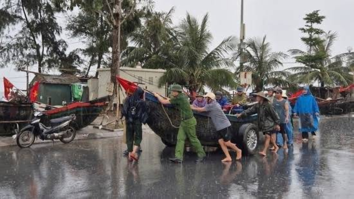
أصدرت السلطات الفيتنامية أوامر بإجلاء أكثر من 586 ألف شخص من المناطق الساحلية الوسطى، تحسبًا لوصول إعصار كاجيكي الذي يتوقع أن يضرب الساحل الشرقي للبلاد صباح الإثنين، ويأتي هذا الإجراء في ظل تحذيرات من هطول أمطار غزيرة، وفيضانات، وانزلاقات أرضية.
وأعلنت السلطات الفيتنامية عن خطط للإجلاء، حيث من المتوقع أن يصل الإعصار كاجيكي إلى اليابسة في ساعات الصباح الأولى من الإثنين، وبحسب المركز الوطني للتنبؤات الهيدرولوجية والأرصاد الجوية في فيتنام، كان الإعصار على بعد نحو 500 كم من السواحل الوسطى للبلاد صباح الأحد، وهو يتحرك غربًا بسرعة 20 كم/ساعة، مع رياح تصل سرعتها إلى 166 كم/ساعة.
ومن المتوقع أن يزداد قوة مع رياح تصل إلى 180 كم/ساعة، وهطول أمطار بمعدل 200 إلى 400 ملم، قد تصل إلى 700 ملم في بعض المناطق، ما يزيد من مخاطر الفيضانات المفاجئة والانزلاقات الأرضية.
وتم إلغاء ما لا يقل عن 22 رحلة جوية تابعة لشركة فيتنام إيرلاينز وفيتجيت إلى المدن الوسطى ومنها يوما الأحد والإثنين، كما تم منع السفن والقوارب من مغادرة الموانئ في سبع مقاطعات من نينه بينه إلى كوانغ نغاي.
وحذرت السلطات من أن الإعصار قد يهدد نحو 300 ألف هكتار من الأرز، و77 ألف هكتار من مزارع الفواكه، و57 ألف هكتار من محاصيل المطاط، بالإضافة إلى 5700 قفص لتربية الأسماك و384 كوخًا ساحليًا، وتم توجيه تعليمات إلى السلطات المحلية لتخفيض مستويات المياه في الخزانات، التي تتراوح بين 71 إلى 82% من سعتها، لتقليل مخاطر الفيضانات في المناطق المنخفضة.
وأشار نائب مدير المركز الوطني للتنبؤات الهيدرولوجية والأرصاد الجوية، هوانغ فوك لام، إلى أن الإعصار كاجيكي «غير عادي» بسبب سرعة تطوره، حيث تحول من اكتئاب استوائي إلى إعصار من الفئة 13-14 في أقل من 48 ساعة، مع هبوب رياح تصل إلى الفئة 17 (ما يعادل 200 كم/ساعة)، وأضاف أن قوته قد ترقى إلى مستوى إعصار ياغي المدمر الذي ضرب فيتنام في سبتمبر 2024، ما أسفر عن مقتل نحو 300 شخص وتسبب في أضرار بقيمة 3.3 مليار دولار.
في الوقت نفسه، أصدرت مدينة سانيا في جزيرة هاينان الصينية تحذيرًا من الإعصار باللون الأحمر، وهو أعلى مستوى في نظام التحذير الصيني، مع إغلاق الشركات والمواصلات العامة وتعليق الدراسة وأعمال البناء، وتم إجلاء نحو 20 ألف شخص من هاينان، حيث من المتوقع أن يمر الإعصار بالقرب من الساحل الجنوبي للجزيرة قبل توجهه إلى فيتنام.
ويُعد إعصار كاجيكي الإعصار الخامس الذي يضرب بحر الصين الجنوبي (المعروف في فيتنام باسم البحر الشرقي) هذا العام، والثالث عشر في المنطقة الأوسع، وتأتي هذه العاصفة في أعقاب سلسلة من الكوارث الطبيعية التي ضربت فيتنام، أبرزها إعصار ياغي في سبتمبر 2024، وهو أقوى إعصار يضرب البلاد منذ ثلاثة عقود، والذي أدى إلى إجلاء أكثر من 50 ألف شخص، وتدمير نحو 190 ألف منزل، وتسبب في انقطاع الكهرباء عن 1.5 مليون شخص.
وتشهد فيتنام موسم أعاصير سنوي يمتد عادة من يونيو إلى نوفمبر، حيث تتعرض البلاد لمتوسط 4 إلى 6 أعاصير أو عواصف استوائية سنويًا، وتُعد المناطق الوسطى والشمالية، مثل ثانه هوا ودانانغ، الأكثر عرضة للأعاصير بسبب موقعها الجغرافي على الساحل الشرقي، كما أن التغيرات المناخية زادت من حدة هذه العواصف، حيث أشار خبراء الأرصاد إلى أن ارتفاع درجات حرارة البحر يؤدي إلى أعاصير أكثر قوة وهطول أمطار أكثر كثافة.
The Vietnamese authorities have issued evacuation orders for more than 586,000 people from the central coastal areas, in anticipation of Typhoon Kajiqi, which is expected to hit the eastern coast of the country on Monday morning. This action comes amid warnings of heavy rainfall, flooding, and landslides.
The Vietnamese authorities announced evacuation plans, as Typhoon Kajiqi is expected to make landfall in the early hours of Monday morning. According to the National Center for Hydrometeorological Forecasting in Vietnam, the typhoon was about 500 km from the central coasts of the country on Sunday morning, moving westward at a speed of 20 km/h, with winds reaching speeds of 166 km/h.
The typhoon is expected to strengthen with winds reaching 180 km/h and rainfall amounts of 200 to 400 mm, which could reach 700 mm in some areas, increasing the risks of flash floods and landslides.
At least 22 flights operated by Vietnam Airlines and VietJet to central cities have been canceled for Sunday and Monday, and ships and boats have been prohibited from leaving ports in seven provinces from Ninh Binh to Quang Ngai.
The authorities warned that the typhoon could threaten about 300,000 hectares of rice, 77,000 hectares of fruit farms, and 57,000 hectares of rubber crops, in addition to 5,700 fish cages and 384 coastal huts. Local authorities have been instructed to lower water levels in reservoirs, which range from 71% to 82% of their capacity, to reduce the risks of flooding in low-lying areas.
Deputy Director of the National Center for Hydrometeorological Forecasting, Hoang Phuc Lam, noted that Typhoon Kajiqi is "unusual" due to its rapid development, as it transitioned from a tropical depression to a category 13-14 typhoon in less than 48 hours, with winds reaching category 17 (equivalent to 200 km/h). He added that its strength could reach the level of the devastating Yagi typhoon that struck Vietnam in September 2024, resulting in the deaths of about 300 people and causing damages worth $3.3 billion.
At the same time, the city of Sanya on China's Hainan Island issued a red alert for the typhoon, the highest level in the Chinese warning system, with businesses and public transport closed, and classes and construction work suspended. About 20,000 people have been evacuated from Hainan, as the typhoon is expected to pass near the southern coast of the island before heading to Vietnam.
Typhoon Kajiqi is the fifth typhoon to hit the South China Sea (known in Vietnam as the East Sea) this year, and the thirteenth in the wider region. This storm comes in the wake of a series of natural disasters that have struck Vietnam, most notably Typhoon Yagi in September 2024, which was the strongest typhoon to hit the country in three decades, leading to the evacuation of more than 50,000 people, the destruction of about 190,000 homes, and power outages affecting 1.5 million people.
Vietnam experiences an annual typhoon season that typically runs from June to November, with the country facing an average of 4 to 6 typhoons or tropical storms each year. The central and northern regions, such as Thanh Hoa and Da Nang, are the most vulnerable to typhoons due to their geographical location on the eastern coast. Additionally, climate change has intensified these storms, as meteorological experts have noted that rising sea temperatures lead to stronger typhoons and heavier rainfall.