
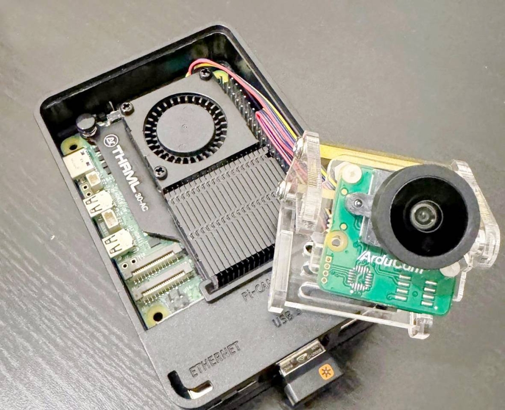
أنجزت جامعة الملك عبدالعزيز مشروعاً بحثياً ابتكارياً يقوم على رصد مخالفات المسار الطارئ على الطرق السريعة في الوقت الفعلي باستخدام الذكاء الاصطناعي عبر فريق علمي طلابي من قسم الجيوماتكس بكلية العمارة والتخطيط، وهو نظام ذكي من خلال جهاز «Raspberry Pi» يقوم بتوظيف تقنيات الرؤية الحاسوبية.
ويعتمد هذا المشروع، الذي طُور بإشراف أساتذة قسم الجيوماتكس (الدكتور كامل فيصل، والدكتور عبدالله العطاس، والدكتور مهند أبو هاشم، والدكتور محمود الخفش)، على خوارزمية «YOLO» لرصد السيارات التي تعتدي على المسارات المخصصة للطوارئ، حيث تم تدريب النموذج باستخدام صور مخصصة، مع تحديد مناطق الاهتمام «ROI» في الفيديو لرصد أي تجاوز للمركبات. ويُعدُّ المشروع الذي شارك فيه الطالبان أنس الحربي، ومحمد المروعي، منخفض التكلفة وعالي الكفاءة، ما يجعله مناسبا لتطبيقات المدن الذكية، وجهات المرور والجهات الحكومية، ويُسهم في تحسين زمن الاستجابة للحالات الطارئة، وإنقاذ الأرواح من خلال ضمان خلو المسارات الطارئة من التعديات.
يذكر أن الجيوماتكس هو تخصص أكاديمي يعنى بالعلوم والتقنيات المتعلقة بالبيانات الجغرافية الرقمية، بما في ذلك المسوحات العمرانية ونظم المعلومات المكانية، ويُطلق عليه أيضا «علم المعطيات الجغرافية» أو «هندسة المساحة الرقمية»، حيث يشمل المعلومات الجغرافية كافة، ومعالجتها، وتحليلها، وعرضها، وتكوين الخرائط، إضافة إلى قياس وإدارة البيانات الجغرافية.
مشروع بحثي ابتكاري بجامعة الملك عبد العزيز يرصد مخالفات المسار الطارئ بالذكاء الاصطناعي
20 يونيو 2025 - 06:54
|
آخر تحديث 20 يونيو 2025 - 06:54
تابع قناة عكاظ على الواتساب
«عكاظ» (جدة) okaz_online@
King Abdulaziz University has completed an innovative research project that monitors violations of emergency lanes on highways in real-time using artificial intelligence, carried out by a scientific student team from the Geomatics Department at the Faculty of Architecture and Planning. This is an intelligent system utilizing a "Raspberry Pi" device that employs computer vision techniques.
This project, developed under the supervision of professors from the Geomatics Department (Dr. Kamel Faisal, Dr. Abdullah Al-Attas, Dr. Mohannad Abu Hashim, and Dr. Mahmoud Al-Khafsh), relies on the "YOLO" algorithm to detect vehicles that violate designated emergency lanes. The model was trained using custom images, with regions of interest (ROI) identified in the video to monitor any vehicle transgressions. The project, in which students Anas Al-Harbi and Mohammed Al-Murouhi participated, is low-cost and highly efficient, making it suitable for smart city applications, traffic authorities, and government entities. It contributes to improving response times for emergencies and saving lives by ensuring that emergency lanes are free from violations.
It is worth mentioning that Geomatics is an academic discipline concerned with the sciences and technologies related to digital geographic data, including urban surveys and spatial information systems. It is also referred to as "Geographic Data Science" or "Digital Survey Engineering," encompassing all geographic information, its processing, analysis, presentation, and map creation, in addition to measuring and managing geographic data.


