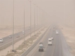
شهدت منطقة حائل وجبل اللوز بمنطقة تبوك (الأربعاء)، تساقطاً كثيفاً للثلوج، تزامن مع تغطية الضباب للمرتفعات، وسط رياح شديدة وانخفاض ملحوظ في درجات الحرارة، إذ وصلت إلى 4 درجات مئوية تحت الصفر.
وينتظر أن يكسي الزائر الأبيض المحبب للنفوس مرتفعات تبوك وحائل، وشمال منطقتي الرياض والقصيم، التي أصبحت على موعد مع فرص تساقط الثلوج (الخميس).
سحب رعدية ممطرة
وأكد المتحدث باسم المركز الوطني للأرصاد أن الفرص مهيأة لنزول الثلج على تلك المناطق مع استمرار نزوله على مرتفعات منطقة تبوك (اللوز، علقان، والظهر) وأجزاء من مرتفعات منطقة حائل، حتى صباح الخميس.
وكان المركز الوطني للأرصاد، أكد في تقريره عن حالة الطقس، احتمالية تساقط الثلوج الخفيفة وتكون الصقيع على أجزاء من مرتفعات منطقتي تبوك وحائل، وكذلك على الأجزاء الشمالية الشرقية من مرتفعات منطقة المدينة المنورة، كما تكون السماء غائمة جزئياً إلى غائمة تتخللها سحب رعدية ممطرة على الأجزاء الغربية والجنوبية الغربية من المملكة.
زخات برد ورياح نشطة
وتوقّع المركز هطول أمطار رعدية متوسطة إلى غزيرة تؤدي إلى جريان السيول مصحوبة بزخات من البرد ورياح نشطة على أجزاء من مناطق الرياض، الشرقية، والحدود الشمالية، في حين تكون متوسطة على أجزاء من مناطق تبوك، الجوف، حائل، والقصيم، مع فرصة تكون الضباب على أجزاء من تلك المناطق.
وسبق أن أعلن المركز الوطني للأرصاد أن أول موجة باردة في فصل الشتاء تشهدها مناطق المملكة نهاية الأسبوع الحالي، مع احتمالية ملامسة درجات الحرارة الصفر المئوي في المناطق الشمالية، وذلك بعد الحالة المطرية التي بدأت يوم الأحد وتستمر حتى الخميس القادم، وتشمل المناطق الـ13، وشهدت كافة مدن المملكة موجة باردة ونزولاً في درجات الحرارة.
The Hail region and Jebel Al-Lawz in the Tabuk area witnessed heavy snowfall on Wednesday, coinciding with fog covering the highlands, amidst strong winds and a noticeable drop in temperatures, reaching 4 degrees Celsius below zero.
The beloved white blanket is expected to cover the highlands of Tabuk and Hail, as well as the northern parts of the Riyadh and Qassim regions, which are set to experience snowfall opportunities on Thursday.
Thunderstorm Clouds with Rain
The spokesperson for the National Center of Meteorology confirmed that conditions are favorable for snowfall in those areas, with continued snowfall on the highlands of the Tabuk region (Al-Lawz, Al-Alaqan, and Al-Dahr) and parts of the Hail highlands, until Thursday morning.
The National Center of Meteorology had previously confirmed in its weather report the possibility of light snowfall and frost formation in parts of the highlands of the Tabuk and Hail regions, as well as in the northeastern parts of the highlands of the Medina region. The sky is expected to be partly to mostly cloudy, interspersed with thunderstorm clouds bringing rain to the western and southwestern parts of the Kingdom.
Hail Showers and Active Winds
The center predicted moderate to heavy thunderstorm rains that would lead to flooding, accompanied by hail showers and active winds in parts of the Riyadh, Eastern, and Northern Borders regions, while moderate rains are expected in parts of the Tabuk, Al-Jawf, Hail, and Qassim regions, with a chance of fog formation in parts of those areas.
The National Center of Meteorology had previously announced that the first cold wave of winter would hit the Kingdom's regions at the end of this week, with temperatures potentially touching zero degrees Celsius in the northern areas, following the rainy conditions that began on Sunday and will continue until next Thursday, affecting all 13 regions, with all cities in the Kingdom experiencing a cold wave and a drop in temperatures.