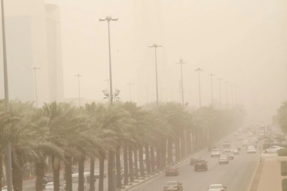
نبّه المركز الوطني للأرصاد بمنطقة تبوك، اليوم، من أتربة مثارة، على الوجه، وأملج تشمل تأثيراتها المصاحبة، رياحاً نشطة، وتدنياً في مدى الرؤية الأفقية (3-5) كم.
وبيّن المركز أن الحالة تستمر حتى الساعة الـ5:00 مساءً.
كما توقّع المركز الوطني للأرصاد في تقريره عن حالة الطقس اليوم استمرار تأثير الرياح النشطة المثيرة للأتربة والغبار على مناطق مكة المكرمة، المدينة المنورة، تبوك، عسير، الباحة، كما لا يستبعد تكوّن الضباب خلال الليل وساعات الصباح الباكر على المنطقة الشرقية.
وأشار التقرير إلى أن حركة الرياح السطحية على البحر الأحمر جنوبية شرقية إلى شرقية تتحول مساءً شمالية شرقية إلى جنوبية شرقية بسرعة 12 - 38كم/ساعة على الجزء الشمالي، وجنوبية شرقية إلى جنوبية على الجزء الأوسط والجنوبي بسرعة 20 - 40كم/ساعة تصل إلى 45 كم/ساعة باتجاه مضيق باب المندب، وارتفاع الموج من نصف المتر إلى متر ونصف على الجزء الشمالي، ومن متر إلى مترين على الجزء الأوسط والجنوبي يصل إلى أعلى من مترين باتجاه مضيق باب المندب، وحالة البحر خفيف إلى متوسط الموج على الجزء الشمالي، ومتوسط الموج على الجزء الأوسط والجنوبي يصل إلى مائج باتجاه مضيق باب المندب.
فيما ستكون حركة الرياح على الخليج العربي شمالية إلى شمالية غربية على الجزء الشمالي والأوسط. وشمالية شرقية إلى شمالية على الجزء الجنوبي بسرعة 15 - 30 كم/ساعة، وارتفاع الموج من نصف المتر إلى متر ونصف، وحالة البحر خفيف الموج.
The National Center of Meteorology in the Tabuk region warned today of raised dust in Al-Wajh and Umluj, with accompanying effects including active winds and a decrease in horizontal visibility (3-5) km.
The center indicated that the condition will continue until 5:00 PM.
Additionally, the National Center of Meteorology forecasted in its weather report for today the continuation of the effects of active winds stirring up dust and sand in the regions of Makkah, Madinah, Tabuk, Asir, and Al-Baha. The formation of fog during the night and early morning hours in the Eastern region is also not ruled out.
The report pointed out that the surface wind movement over the Red Sea will be from the southeast to the east, shifting in the evening to the northeast and southeast at a speed of 12 - 38 km/h in the northern part, and from the southeast to the south in the central and southern parts at a speed of 20 - 40 km/h, reaching up to 45 km/h towards the Bab el-Mandeb Strait. The wave height will range from half a meter to one and a half meters in the northern part, and from one meter to two meters in the central and southern parts, reaching over two meters towards the Bab el-Mandeb Strait. The sea condition will be light to moderate in the northern part, and moderate in the central and southern parts, becoming rough towards the Bab el-Mandeb Strait.
Meanwhile, the wind movement in the Arabian Gulf will be from the north to the northwest in the northern and central parts, and from the northeast to the north in the southern part at a speed of 15 - 30 km/h, with wave heights ranging from half a meter to one and a half meters, and the sea condition will be light.