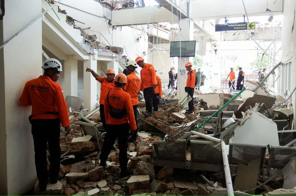
ضرب زلزال قوي قبالة سواحل شرق إندونيسيا، صباح اليوم (السبت)، ما أسفر عن مقتل 38 شخصًا وإصابة 13 آخرين، فيما هرعت فرق الإنقاذ إلى المناطق الأكثر تضررًا، وسط تقارير عن انهيار مبانٍ وانهيارات أرضية قطعت طرقًا وأعاقت الوصول إلى المناطق القريبة من مركز الزلزال.
وبلغت قوة الزلزال 7.7 درجة، وفق هيئة الجيوفيزياء الإندونيسية، ووقع على عمق 15 كيلومترًا، قبل أن تتبعه عشرات الهزات الارتدادية.
38 قتيلًا وعشرات المصابين
وقال رئيس الوكالة الوطنية لإدارة الكوارث في إندونيسيا سوهاريانتو، خلال مؤتمر صحفي متلفز، إن حصيلة الضحايا بلغت حتى الساعة الثالثة عصرًا بالتوقيت المحلي 38 وفاة، وإصابة شخصين بجروح خطيرة و11 آخرين بإصابات طفيفة.
وأضاف أن نحو 2000 شخص فروا إلى مناطق أكثر أمنًا عقب الزلزال، بينما لا يزال سكان محاصرون داخل عدد من المباني المتضررة في المناطق المنكوبة.
وفي مدينة ماوميري الساحلية، عثرت فرق الإنقاذ على 20 جثة، فيما أصيب 6 أشخاص، ولا يزال شخصان عالقين تحت الأنقاض، وفقًا لفاثور رحمان، رئيس هيئة الإنقاذ في المدينة.
وتعد ماوميري المدينة الرئيسية في منطقة سيكا بجزيرة فلوريس، الواقعة شرقي الأرخبيل الإندونيسي.
انهيارات أرضية تعرقل جهود الإنقاذ
وتواجه فرق الإنقاذ صعوبة كبيرة في الوصول إلى منطقة ناجيكيو، الأقرب إلى مركز الزلزال، بسبب الانهيارات الأرضية التي أغلقت الطرق وأثرت على الاتصالات.
وقال رحمان إن فرق الإنقاذ حاولت الوصول إلى المنطقة عبر السيارات، لكن الانهيارات الأرضية حالت دون ذلك، بينما تحاول فرقة أخرى الوصول إليها عبر العبّارات.
وأفادت وكالة إدارة الكوارث بأن نحو 2000 من سكان ناجيكيو تم إجلاؤهم، مع تسجيل أضرار في عدد من المنازل والمخازن والمنشآت الحكومية، فضلًا عن انقطاع الكهرباء وازدحامات مرورية في أجزاء من المنطقة.
كما أشار حاكم إقليم نوسا تنغارا الشرقية، إيمانويل ميلكيادس لاكا لينا، إلى أن خمسة أشخاص على الأقل لقوا حتفهم جراء انهيار الأنقاض عليهم أثناء نومهم.
مشاهد مرعبة لحظة وقوع الزلزال
وأظهرت مشاهد مصورة من أحد موانئ ماوميري، أجزاء من مبنى وهي تنهار إلى كتل من الغبار والأنقاض، بينما كان أشخاص يصرخون ويفرون إلى الشوارع.
وامتدت الهزات القوية إلى مناطق واسعة من إقليم نوسا تنغارا الشرقية والغربية، وأجزاء من إقليم سولاويسي الجنوبية، فيما أفاد سكان في عدة مناطق بأن الاهتزاز استمر لنحو دقيقة.
تسونامي بأمواج أقل من متر
وأعقب الزلزال تحذير من خطر حدوث تسونامي، بعدما سجلت عدة مناطق إندونيسية أمواجًا يقل ارتفاعها عن متر واحد.
لكن السلطات رفعت تحذير التسونامي بعد نحو ثلاث ساعات من وقوع الزلزال، فيما أكدت أستراليا أن الزلزال البحري لا يشكل خطرًا من أمواج تسونامي على البر الرئيسي الأسترالي أو جزرها وأقاليمها.
وفي الوقت نفسه، أظهرت لقطات تلفزيونية نقلها «كومباس تي في» مستشفى في منطقة إندي بإقليم نوسا تنغارا الشرقية وهو ينقل المرضى إلى الخارج تحسبًا لأي هزات ارتدادية أو انهيارات إضافية.
عشرات الهزات الارتدادية
وسجلت هيئة الجيوفيزياء الإندونيسية الزلزال الرئيسي في الساعة 4:58 صباحًا بالتوقيت المحلي، على عمق 15 كيلومترًا، قبل وقوع عدد من الهزات الارتدادية.
وتعيد الكارثة إلى الأذهان زلزالًا مدمرًا ضرب المنطقة نفسها عام 1992 وبلغت قوته 7.5 درجة، وتسبب آنذاك في دمار واسع.
وتقع إندونيسيا ضمن ما يعرف بـ«حلقة النار في المحيط الهادئ»، وهي منطقة شديدة النشاط الزلزالي والبركاني تمتد على طول مناطق التقاء الصفائح التكتونية، ما يجعل الأرخبيل الإندونيسي عرضة بصورة متكررة للزلازل والثوران البركاني.
A strong earthquake struck off the eastern coast of Indonesia this morning (Saturday), resulting in the death of 38 people and injuring 13 others, as rescue teams rushed to the most affected areas amid reports of building collapses and landslides that blocked roads and hindered access to areas near the earthquake's epicenter.
The earthquake had a magnitude of 7.7, according to the Indonesian Geophysics Agency, and occurred at a depth of 15 kilometers, followed by dozens of aftershocks.
38 Dead and Dozens Injured
The head of Indonesia's National Disaster Management Agency, Suharyanto, stated during a televised press conference that the death toll had reached 38 by 3 PM local time, with two people seriously injured and 11 others sustaining minor injuries.
He added that around 2,000 people fled to safer areas following the earthquake, while residents remain trapped inside several damaged buildings in the affected areas.
In the coastal city of Maumere, rescue teams found 20 bodies, while 6 people were injured, and two others are still trapped under the rubble, according to Vathur Rahman, head of the rescue agency in the city.
Maumere is the main city in the Sikka region on Flores Island, located in the eastern part of the Indonesian archipelago.
Landslides Hinder Rescue Efforts
Rescue teams are facing significant difficulties in reaching the Najikio area, closest to the earthquake's epicenter, due to landslides that have blocked roads and affected communications.
Rahman stated that rescue teams attempted to reach the area by vehicle, but landslides prevented this, while another team is trying to access it via ferries.
The disaster management agency reported that about 2,000 residents of Najikio have been evacuated, with damage recorded in several homes, warehouses, and government facilities, in addition to power outages and traffic congestion in parts of the area.
The governor of East Nusa Tenggara, Emanuel Melkiades Laka Lena, also noted that at least five people died due to debris collapsing on them while they were sleeping.
Terrifying Scenes at the Moment of the Earthquake
Footage from one of the ports in Maumere showed parts of a building collapsing into clouds of dust and debris, while people screamed and fled into the streets.
The strong tremors extended over wide areas of East and West Nusa Tenggara provinces, and parts of South Sulawesi province, with residents in several areas reporting that the shaking lasted for about a minute.
Tsunami with Waves Less Than One Meter
Following the earthquake, a tsunami warning was issued after several Indonesian areas recorded waves less than one meter high.
However, authorities lifted the tsunami warning about three hours after the earthquake, while Australia confirmed that the offshore earthquake posed no tsunami threat to the Australian mainland or its islands and territories.
Meanwhile, television footage broadcast by "Kompas TV" showed a hospital in the Ende area of East Nusa Tenggara evacuating patients outdoors in anticipation of any aftershocks or additional collapses.
Dozens of Aftershocks
The Indonesian Geophysics Agency recorded the main earthquake at 4:58 AM local time, at a depth of 15 kilometers, before a series of aftershocks occurred.
This disaster recalls a devastating earthquake that struck the same region in 1992, which had a magnitude of 7.5 and caused widespread destruction at that time.
Indonesia is located within what is known as the "Ring of Fire" in the Pacific, a region of high seismic and volcanic activity that extends along tectonic plate boundaries, making the Indonesian archipelago frequently susceptible to earthquakes and volcanic eruptions.