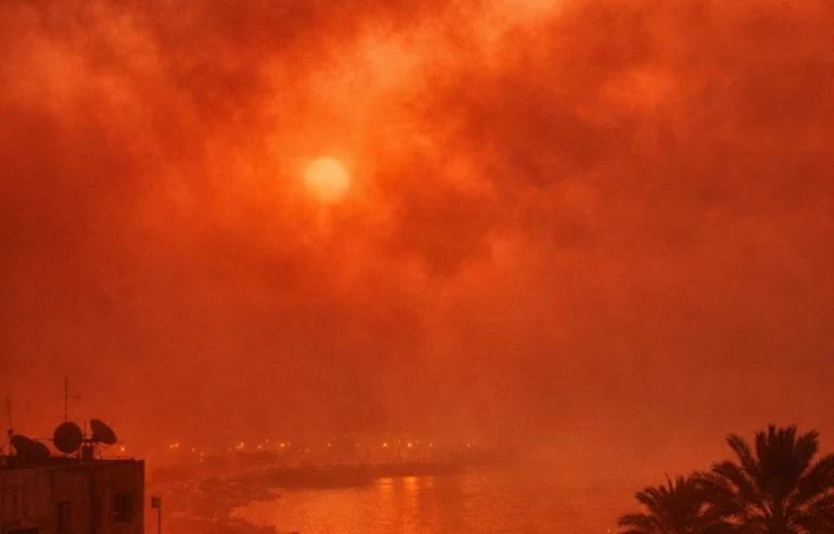
في الأيام الأخيرة، انتشرت على مواقع التواصل الاجتماعي في مصر صور وفيديوهات صادمة تظهر سماء بلون أحمر دموي كثيف، مع انعدام شبه كامل للرؤية، وأطلق عليها البعض اسم «العاصفة الدموية».
الظاهرة بدأت بشكل بارز في ليبيا، ثم امتدت إلى جزيرة كريت اليونانية ومناطق أخرى في حوض البحر المتوسط، ما أثار حالة من القلق والتساؤلات حول إمكانية وصولها إلى مصر.
ما هي «العاصفة الدموية» علمياً
رغم الاسم المثير الذي يوحي بالدراما، فإن «العاصفة الدموية» أو «العاصفة الحمراء» ليست مصطلحاً علمياً رسمياً، بل وصف بصري لعواصف غبارية صحراوية شديدة، تنشأ عندما تهب رياح قوية مرتبطة بمنخفضات جوية، فترفع ملايين الأطنان من الرمال والغبار الدقيق من الصحراء الكبرى.
ويحتوي هذا الغبار على نسب عالية من أكاسيد الحديد (الصدأ)، التي تشتت أشعة الشمس وتعطي السماء لوناً أحمر أو برتقالياً داكناً، يشبه مشهداً من فيلم خيال علمي.
في ليبيا، تسببت العاصفة في تدهور حاد للرؤية الأفقية، وارتباك في حركة التنقل، وغلاف كثيف من الغبار غطى المدن، كما امتد تأثير مشابه إلى اليونان، حيث تحولت سماء كريت إلى اللون الأحمر الداكن في الأول من أبريل، ما أدى إلى اضطرابات في الرحلات الجوية وانخفاض الرؤية.
موقف مصر من الظاهرة
بدورها، حسمت الهيئة العامة للأرصاد الجوية المصرية الجدل بشكل قاطع، حيث أكدت عضو المركز الإعلامي بالهيئة منار غانم أن ما يتردد عن تعرض مصر لـ«عاصفة دموية» أو رملية قوية خلال الفترة القادمة عارٍ تماماً من الصحة، وهي مجرد شائعات تسبب ذعراً غير مبرر.
وأوضحت أن التأثير على مصر كان محدوداً جداً، واقتصر على أقصى الحدود الغربية في منطقة السلوم، وبشدة أخف بكثير مما حدث في ليبيا، وقد انتهى تماماً مع تحرك العاصفة.
من جانبه، أشار مدير إدارة التحليل والتنبؤات بالهيئة محمود شاهين إلى أن الكتل الهوائية المؤثرة على مصر حالياً تختلف عن تلك في ليبيا، ما يمنع انتقال التأثير القوي، وأكدت الهيئة أنها تتابع صور الأقمار الصناعية وخرائط الطقس لحظياً، وستعلن عن أي ظاهرة جوية مؤثرة مسبقاً بوقت كافٍ.
وشهدت مصر أخيراً بعض العواصف الترابية العادية في مناطق متفرقة، مصحوبة برياح وأتربة، لكنها لم تصل إلى مستوى «الدموية» الذي رُصد في ليبيا واليونان، فيما يتجه الطقس في البلاد نحو الاستقرار النسبي خلال الأيام القادمة، دون مؤشرات على تقلبات حادة أو عواصف غبارية شديدة.
نصائح وقائية
ونصحت الهيئة العامة للأرصاد الجوية المصرية بالالتزام بالتعليمات التي وضعتها في حال ظهور عواصف ترابية، وهي البقاء في المنازل قدر الإمكان، خصوصاً كبار السن وأصحاب الأمراض التنفسية، ارتداء الكمامات إذا لزم الأمر، وإغلاق النوافذ جيداً، تجنب القيادة في حال انخفاض الرؤية، والابتعاد عن اللوحات الإعلانية والأشجار.
In recent days, shocking images and videos have spread on social media in Egypt showing a sky with a dense blood-red color, with almost complete lack of visibility, and some have dubbed it the "bloodstorm."
The phenomenon began prominently in Libya, then extended to the Greek island of Crete and other areas in the Mediterranean basin, raising concerns and questions about the possibility of it reaching Egypt.
What is the "bloodstorm" scientifically
Despite the dramatic name that suggests a sense of urgency, the "bloodstorm" or "red storm" is not an official scientific term, but rather a visual description of severe dust storms that arise when strong winds associated with low-pressure systems lift millions of tons of sand and fine dust from the Sahara Desert.
This dust contains high levels of iron oxides (rust), which scatter sunlight and give the sky a dark red or orange color, resembling a scene from a science fiction movie.
In Libya, the storm caused a sharp deterioration in horizontal visibility, confusion in transportation, and a thick layer of dust that covered the cities, while a similar effect extended to Greece, where the sky in Crete turned dark red on April 1, leading to flight disruptions and reduced visibility.
Egypt's stance on the phenomenon
For its part, the Egyptian Meteorological Authority has decisively settled the debate, with media center member Manar Ghanem confirming that reports about Egypt being exposed to a "bloodstorm" or a strong sandstorm in the coming period are completely unfounded, and are merely rumors causing unwarranted panic.
She clarified that the impact on Egypt was very limited, confined to the far western borders in the Sallum area, and was much less severe than what occurred in Libya, having completely ended with the movement of the storm.
For his part, Mahmoud Shaheen, director of the analysis and forecasting department at the authority, pointed out that the air masses affecting Egypt currently differ from those in Libya, preventing the strong impact from transferring, and the authority confirmed that it is continuously monitoring satellite images and weather maps, and will announce any significant weather phenomena in advance with sufficient notice.
Recently, Egypt has witnessed some ordinary dust storms in various areas, accompanied by winds and dust, but they did not reach the "bloody" level observed in Libya and Greece, while the weather in the country is trending towards relative stability in the coming days, with no indications of severe fluctuations or intense dust storms.
Preventive advice
The Egyptian Meteorological Authority advised adhering to the guidelines it has set in case of dust storms, which include staying indoors as much as possible, especially for the elderly and those with respiratory diseases, wearing masks if necessary, securely closing windows, avoiding driving in case of reduced visibility, and keeping away from billboards and trees.