أمر الرئيس الفلبيني فيرديناند ماركوس جونيور وكالة الاستجابة للكوارث في الفلبين بالدخول في حالة تأهب قصوى وتعبئة جميع الجهات الحكومية، مع اقتراب إعصار «راغاسا» الفائق القوة من شمال البلاد، مما أثار إنذارات عاصفة في شرق وجنوب شرق آسيا.
إعصار راغاسا
وفقًا لوكالة الأرصاد الجوية الحكومية، هبط الإعصار على جزيرة كالايان في مقاطعة كاغايان، حاملاً رياحًا تصل سرعتها إلى 215 كم/ساعة (134 ميل/ساعة)، ورياحًا عاتية تصل إلى 295 كم/ساعة (160 ميل/ساعة)، مما يرفع مخاطر ارتفاع مستوى سطح البحر إلى أكثر من ثلاثة أمتار (تسعة أقدام).
ويُعرف الإعصار محليًا باسم «ناندو»، وهو العاصفة الـ14 هذا العام، وقد تصاعد إلى إعصار فائق القوة في 21 سبتمبر 2025 شرق كاغايان.
وبقيت جزر بابويان تحت إنذار عاصفة عالي المستوى، حيث نصحت السلطات السكان بالابتعاد عن المناطق الساحلية وممرات الأنهار.
وأظهرت مقاطع فيديو من وكالات الإغاثة كيف يضرب الإعصار مقاطعة كاغايان الشمالية برياح شديدة وأمطار غزيرة، مما يثير أمواجًا قوية ويهز الأشجار بعنف.
إجراءات حكومية
وأوقفت الحكومة العمل والدراسة في متروبوليتان مانيلا ومعظم أجزاء لوزون، مع تحذيرات من انقطاع الكهرباء، والانهيارات الأرضية، والفيضانات، والبحار الخطرة. وألغت شركات الطيران نحو 24 رحلة داخلية، معظمها إلى مراكز لوزون الرئيسية، بينما علقت الموانئ خدمات العبارات.
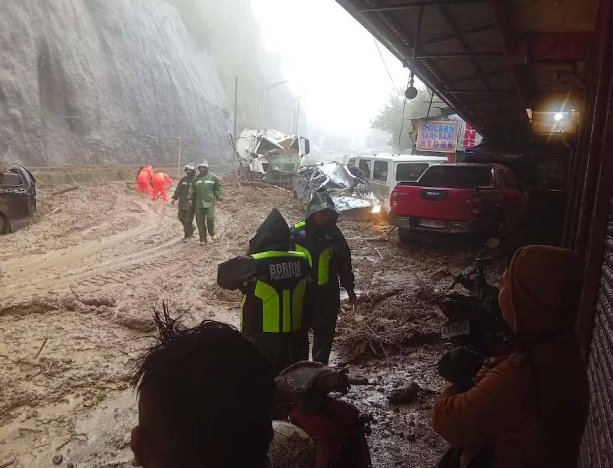
وفي منطقة توبا بمقاطعة بينغويت، أجرت فرق الإنقاذ عمليات تنظيف طرق بعد انهيار أرضي، كما أفادت الشرطة المحلية.
التأثيرات الإقليمية
على الرغم من عدم اصطدام «راغاسا» المباشر بتايوان، إلا أن أطرافه الخارجية ستجلب أمطارًا غزيرة إلى الساحل الشرقي النائي سكانيًا، مما دفع تايوان إلى إصدار إنذارات برية وبحرية، وإلغاء 146 رحلة داخلية، وإجلاء أكثر من 900 شخص من المناطق الجبلية في الجنوب والشرق.
وأمرت وزارة الدفاع الفيتنامية قواتها بالمراقبة والاستعداد لإمكان هبوط الإعصار أواخر هذا الأسبوع.
وفي الصين، فعّلت السلطات إجراءات مكافحة الفيضانات في عدة مقاطعات جنوبية، محذرة من أمطار غزيرة تبدأ مساء (الثلاثاء).
أما هونغ كونغ، فقد أعلنت أن مطارها سيبقى مفتوحًا لكن العمليات ستُقلص، مع تقليل الرحلات بعد الساعة 6 مساءً (10 صباحًا بتوقيت غرينتش) الثلاثاء، وتأثر معظم الرحلات الأربعاء، حيث ألغت كاثاي باسيفيك نحو 500 رحلة.
مسار إعصار راغاسا
ويتوقع مسار الإعصار أن يمر قريبًا من أو فوق جزر باتانيس وبابويان بعد الظهر والمساء 22 سبتمبر، قبل الخروج من منطقة المسؤولية الفلبينية صباح 23 سبتمبر، ثم يتجه جنوب تايوان وهونغ كونغ مع رياح تصل إلى 200 كم/ساعة وأعلى.
يُعد «راغاسا» أقوى إعصار هذا العام حتى الآن، مع سرعات رياح مستمرة تصل إلى 257 كم/ساعة، مما يعادل إعصارًا من الفئة 5، ويُتوقع أن يضعف تدريجيًا بسبب التفاعل الطبوغرافي مع لوزون وارتفاع قص الرياح عند اقترابه من جنوب الصين.
The Philippine President Ferdinand Marcos Jr. has ordered the Philippine Disaster Response Agency to enter a state of maximum alert and mobilize all government agencies as Super Typhoon "Ragasa" approaches the northern part of the country, triggering storm alerts in East and Southeast Asia.
Typhoon Ragasa
According to the government weather agency, the typhoon made landfall on Calayan Island in Cagayan province, bringing winds of up to 215 km/h (134 mph) and gusts reaching 295 km/h (160 mph), raising the risk of storm surges of over three meters (nine feet).
The typhoon is locally known as "Nando," and it is the 14th storm this year, having intensified into a super typhoon on September 21, 2025, east of Cagayan.
The Babuyan Islands remain under a high-level storm alert, with authorities advising residents to stay away from coastal areas and river pathways.
Videos from relief agencies showed the typhoon hitting the northern Cagayan province with strong winds and heavy rains, creating powerful waves and violently shaking trees.
Government Actions
The government suspended work and classes in Metropolitan Manila and most parts of Luzon, with warnings of power outages, landslides, flooding, and dangerous seas. Airlines canceled about 24 domestic flights, mostly to major Luzon hubs, while ports suspended ferry services.
In the Tuba area of Benguet province, rescue teams conducted road clearing operations after a landslide, local police reported.
Regional Impacts
Although "Ragasa" is not making direct landfall in Taiwan, its outer bands will bring heavy rains to the sparsely populated eastern coast, prompting Taiwan to issue land and sea warnings, cancel 146 domestic flights, and evacuate over 900 people from mountainous areas in the south and east.
The Vietnamese Ministry of Defense has ordered its forces to monitor and prepare for the possible landfall of the typhoon later this week.
In China, authorities activated flood control measures in several southern provinces, warning of heavy rains starting Tuesday evening.
As for Hong Kong, it announced that its airport would remain open but operations would be reduced, with fewer flights after 6 PM (10 AM GMT) on Tuesday, and most flights affected on Wednesday, as Cathay Pacific canceled around 500 flights.
Path of Typhoon Ragasa
The expected path of the typhoon is to pass near or over the Batanes and Babuyan Islands in the afternoon and evening of September 22, before exiting the Philippine area of responsibility on the morning of September 23, then heading towards southern Taiwan and Hong Kong with winds reaching 200 km/h and higher.
"Ragasa" is the strongest typhoon of the year so far, with sustained wind speeds of up to 257 km/h, equivalent to a Category 5 hurricane, and it is expected to gradually weaken due to topographical interaction with Luzon and increasing wind shear as it approaches southern China.