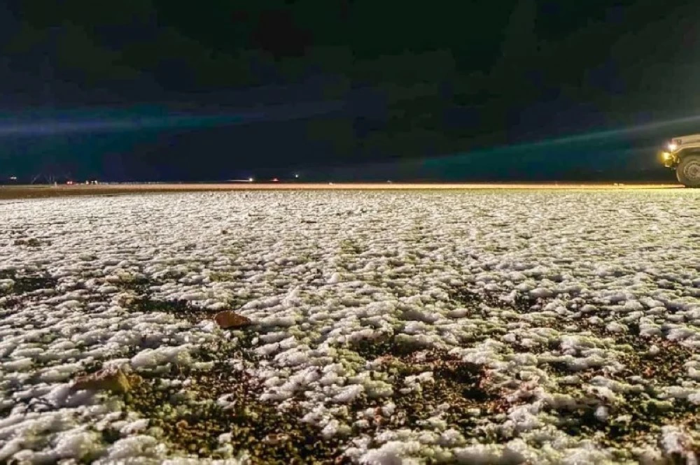
شهدت أجزاء من منطقة حائل مساء أمس، تساقط الثلوج على أجزاء متفرقة من أطراف مدينة حائل، صاحبها هطول أمطار من خفيفة إلى متوسطة على المنطقة وعدد من محافظاتها.
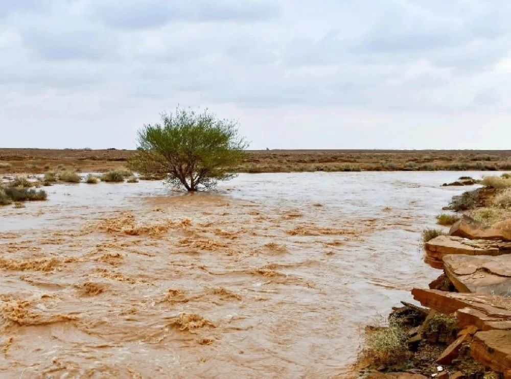
يذكر ان المركز الوطني للارصاد توقعفي تقريره عن حالة الطقس هذا اليوم (الخميس)، استمرار هطول أمطار رعدية متوسطة إلى غزيرة تؤدي إلى جريان السيول مصحوبة بزخات من البرد، ورياح نشطة على أجزاء من مناطق: الشرقية، الرياض، القصيم، وتكون خفيفة إلى متوسطة على أجزاء من مناطق: الحدود الشمالية، الجوف، حائل، وكذلك على الأجزاء الجنوبية الغربية من المملكة مع فرصة تكون الضباب على أجزاء من تلك المناطق.
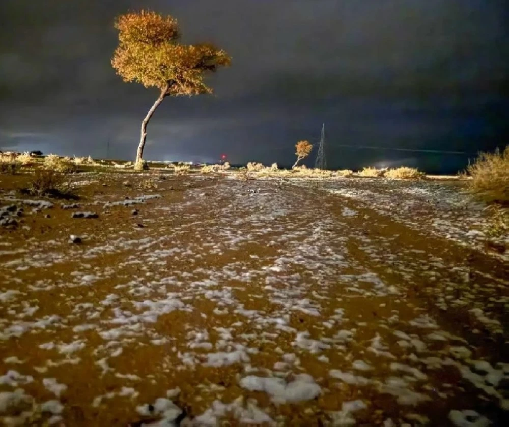
وأشار المركز، إلى احتمالية تساقط الثلوج على أجزاء من مناطق: حائل، القصيم، تمتد إلى الأجزاء الشمالية من منطقة الرياض، كما تنشط الرياح السطحية المثيرة للأتربة والغبار على معظم مناطق المملكة خصوصا على الأجزاء الساحلية، في حين يكون الطقس باردا إلى شديد البرودة على شمال غرب المملكة.
حركة الرياح السطحية
وبين المركز الوطني للارصاد أن حركة الرياح السطحية على البحر الأحمر، شمالية غربية إلى شمالية شرقية بسرعة 25-50 كم/ساعة وعلى الجزء الجنوبي بسرعة 15-35 كم/ساعة تصل إلى 60كم/ساعة مع تكون السحب الرعدية الممطرة، وارتفاع الموج من متر ونصف إلى مترين ونصف على الجزء الشمالي والأوسط ومن نصف المتر إلى متر ونصف يصل إلى مترين ونصف مع تكون السحب الرعدية الممطرة على الجزء الجنوبي، وحالة البحر متوسط الموج إلى مائج على الجزء الشمالي والأوسط وخفيف إلى متوسط الموج يصل إلى مائج مع تكون السحب الرعدية الممطرة على الجزء الجنوبي.
وعلى الخليج العربي ستكون حركة الرياح السطحية شمالية غربية إلى غربية بسرعة 25-50 كم/ساعة تصل إلى أكثر من 60 كم/ساعة مع تكون السحب الرعدية الممطرة، وارتفاع الموج من متر ونصف إلى مترين ونصف يصل إلى أعلى مترين ونصف مع تكون السحب الرعدية الممطرة، وحالة البحر متوسط الموج إلى مائج.
Parts of the Hail region witnessed snowfall yesterday evening in scattered areas on the outskirts of the city of Hail, accompanied by light to moderate rain across the region and several of its governorates.
The National Center of Meteorology mentioned in its weather report for today (Thursday) that medium to heavy thunderstorm rains are expected to continue, leading to flash floods, accompanied by hail showers and active winds in parts of the Eastern, Riyadh, and Qassim regions, while being light to moderate in parts of the Northern Borders, Al-Jawf, Hail, as well as in the southwestern parts of the Kingdom, with a chance of fog formation in parts of those areas.
The center also indicated the possibility of snowfall in parts of the Hail and Qassim regions, extending to the northern parts of the Riyadh region. Additionally, surface winds that stir up dust and sand are expected to be active in most parts of the Kingdom, especially in coastal areas, while the weather will be cold to very cold in the northwest of the Kingdom.
Surface Wind Movement
The National Center of Meteorology stated that the surface wind movement over the Red Sea is from the northwest to the northeast at a speed of 25-50 km/h, and in the southern part at a speed of 15-35 km/h, reaching up to 60 km/h with the formation of thunderstorm clouds. The wave height ranges from one and a half to two and a half meters in the northern and central parts, and from half a meter to one and a half meters, reaching two and a half meters with the formation of thunderstorm clouds in the southern part. The sea condition is moderate to rough in the northern and central parts and light to moderate, reaching rough with the formation of thunderstorm clouds in the southern part.
In the Arabian Gulf, the surface wind movement will be from the northwest to the west at a speed of 25-50 km/h, reaching more than 60 km/h with the formation of thunderstorm clouds. The wave height ranges from one and a half to two and a half meters, reaching over two and a half meters with the formation of thunderstorm clouds, and the sea condition is moderate to rough.