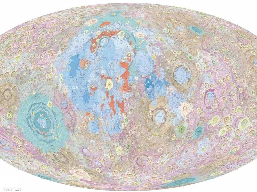
أعلنت الصين إنجاز نسخة محدثة من الخريطة الجيولوجية الكاملة للقمر بمقياس 1:5 مليون، في خطوة علمية تعزز طموحاتها في استكشاف الفضاء وبناء محطة أبحاث على سطح القمر. وتوفر الخريطة أحدث تصوير للتكوينات الجيولوجية والتاريخ التطوري للقمر، مع تحديثات غير مسبوقة في تصنيف الصخور والحقب الجيولوجية، ما يجعلها مرجعًا علميًا جديدًا لمهام الهبوط والاستكشاف المستقبلية.
خريطة ترصد آلاف الفوهات والأحواض
وأوضح معهد الجيولوجيا التابع للأكاديمية الصينية للعلوم الجيولوجية، وفقًا لوكالة الأنباء الصينية «شينخوا»، أن الخريطة الجديدة، التي يبلغ طولها نحو 280 سنتيمترًا وارتفاعها 120 سنتيمترًا، تتضمن خرائط تفصيلية للمناطق القطبية للقمر، وتوثق بدقة أكثر من 13 ألف فوهة اصطدام و81 حوضًا اصطداميًا، إضافة إلى تحديد 14 نوعًا من التراكيب الجيولوجية و17 نوعًا من الصخور على سطحه.
تحديث شامل للتاريخ الجيولوجي للقمر
واستند الفريق البحثي إلى أحدث نتائج برنامج «تشانغ آه» الصيني لاستكشاف القمر، إلى جانب الدراسات العلمية الحديثة، لإجراء مراجعة شاملة للجدول الزمني الجيولوجي للقمر وتصنيف مواده وطريقة تمثيل معالمه الجيولوجية.
وأعاد الباحثون تحديد بدايات ثلاثة من أبرز العصور الجيولوجية القمرية، وهي أيتكينيان ونيكتاريان وإمبريان، عند 4.33 مليار و4.17 مليار و3.92 مليار سنة على التوالي، كما تقدم الخريطة لأول مرة عالميًا تقسيمًا أكثر دقة للوحدات الطبقية التي توثق المراحل المتأخرة من التاريخ الجيولوجي للقمر.
معادن وصخور بتفاصيل غير مسبوقة
وتضم الخريطة بيانات عالية الدقة لتوزيع المعادن الرئيسية على سطح القمر، مع تطوير نظام تصنيف الصخور. كما أضيف صخر الغابرونوريت بوصفه نوعًا صخريًا مستقلًا داخل حوض القطب الجنوبي – أيتكن، استنادًا إلى نتائج مهمتي «تشانغ آه-4» و«تشانغ آه-6».
وللحفاظ على وضوح الخريطة رغم كثافة المعلومات، اعتمد الباحثون معايير مختلفة للحد الأدنى من التفاصيل المرسومة لكل فئة من المعالم الجيولوجية، بما يضمن سهولة قراءتها دون المساس بقيمتها العلمية.
تمهيد لمحطة أبحاث على سطح القمر
وتأتي هذه الخريطة امتدادًا لإنجازات الصين في رسم خرائط القمر، بعد إصدار أول خريطة جيولوجية كاملة للعالم بمقياس 1:2.5 مليون عام 2022، ثم نشر أول أطلس جيولوجي قمري عالي الدقة عام 2024.
وأكد مدير المعهد يانغ تشيمينغ أن الخريطة الجديدة ستشكل مرجعًا علميًا مهمًا لدعم إنشاء محطة الأبحاث القمرية الصينية المستقبلية، واختيار مواقع الهبوط، وتخطيط مهام استكشاف الفضاء العميق، مشيرًا إلى أنها تمثل إضافة علمية صينية جديدة تسهم في فهم تطور القمر والنظام الشمسي.
China has announced the completion of an updated version of the comprehensive geological map of the Moon at a scale of 1:5 million, in a scientific step that enhances its ambitions in space exploration and the construction of a research station on the lunar surface. The map provides the latest imaging of the geological formations and evolutionary history of the Moon, with unprecedented updates in rock classification and geological eras, making it a new scientific reference for future landing and exploration missions.
A Map Tracking Thousands of Craters and Basins
The Geological Institute of the Chinese Academy of Geological Sciences explained, according to the Chinese news agency "Xinhua," that the new map, which measures approximately 280 centimeters in length and 120 centimeters in height, includes detailed maps of the lunar polar regions, accurately documenting more than 13,000 impact craters and 81 impact basins, in addition to identifying 14 types of geological structures and 17 types of rocks on its surface.
Comprehensive Update of the Moon's Geological History
The research team relied on the latest results from China's "Chang'e" lunar exploration program, along with recent scientific studies, to conduct a comprehensive review of the lunar geological timeline and classify its materials and the representation of its geological features.
The researchers redefined the beginnings of three of the most prominent lunar geological eras, namely the Aitkenian, Nectarian, and Imbrian, at 4.33 billion, 4.17 billion, and 3.92 billion years, respectively. The map also provides, for the first time globally, a more precise division of the stratigraphic units that document the later stages of the Moon's geological history.
Minerals and Rocks with Unprecedented Detail
The map includes high-resolution data on the distribution of major minerals on the lunar surface, along with the development of a rock classification system. Additionally, gabbro was added as an independent rock type within the South Pole-Aitken basin, based on the results of the "Chang'e-4" and "Chang'e-6" missions.
To maintain the clarity of the map despite the density of information, the researchers adopted different standards for the minimum detail drawn for each category of geological features, ensuring ease of reading without compromising its scientific value.
Paving the Way for a Research Station on the Moon
This map comes as an extension of China's achievements in mapping the Moon, following the release of the first complete geological map of the world at a scale of 1:2.5 million in 2022, and then the publication of the first high-resolution lunar geological atlas in 2024.
The director of the institute, Yang Qiming, confirmed that the new map will serve as an important scientific reference to support the establishment of the future Chinese lunar research station, the selection of landing sites, and the planning of deep space exploration missions, noting that it represents a new Chinese scientific contribution that aids in understanding the evolution of the Moon and the solar system.