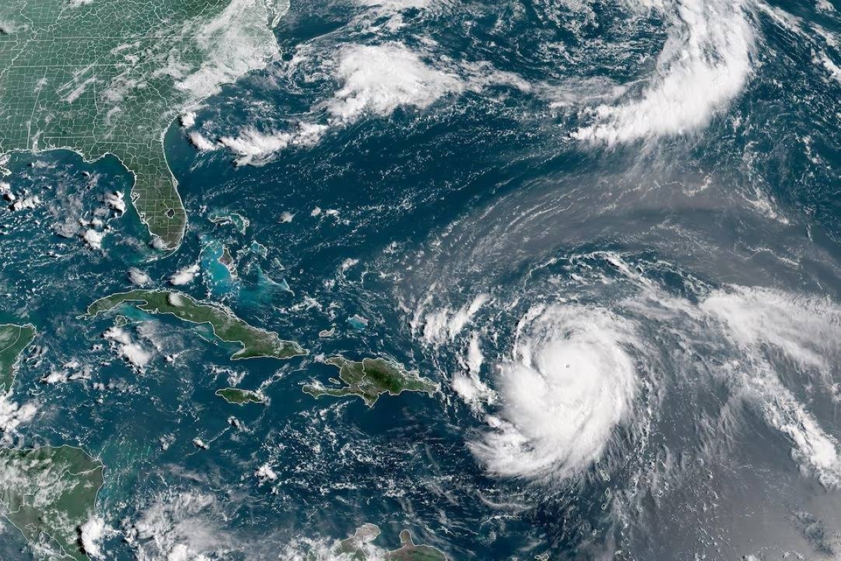
أعلن المركز الوطني الأمريكي للأعاصير، في ساعة مبكرة من اليوم (الأحد) 17 أغسطس 2025، أن إعصار إيرين، أول إعصار في موسم الأعاصير الأطلسية 2025، تراجع إلى الفئة الثالثة بعد انخفاض طفيف في سرعة رياحه.
ويقع الإعصار حاليًا على بعد حوالى 330 ميلاً (530 كم) شرق-جنوب شرق جزيرة غراند تورك، مع رياح مستمرة تصل سرعتها القصوى إلى 125 ميلاً في الساعة (205 كم/س).
وكان إعصار إيرين قد صُنف سابقًا كإعصار كارثي من الفئة الخامسة بسرعة رياح قصوى بلغت 160 ميلاً في الساعة (240 كم/س)، قبل أن يُخفض إلى الفئة الرابعة.
وكانت التوقعات تشير إلى احتمالية تعززه خلال الأسبوع، لكنه شهد تراجعًا في الشدة، وألغت الخدمات الجوية الفرنسية والهولندية تحذيرات العاصفة الاستوائية لجزر سانت مارتن، وسانت بارتيليمي، وسينت مارتن.
ويتحرك إيرين حاليًا غرب-شمال غرب بسرعة 14 ميلاً في الساعة (22 كم/س)، مع توقعات بانخفاض سرعته خلال الأحد، وتحوله نحو الشمال يومي الإثنين والثلاثاء، ومن المتوقع أن يمر الإعصار شرق جزر توركس وكايكوس وجنوب شرق جزر الباهاما ليلة الأحد والإثنين.
وتتسبب الأمواج الناتجة عن إيرين في تأثيرات على جزر ليوارد الشمالية، جزر العذراء، بورتو ريكو، هيسبانيولا، وجزر توركس وكايكوس خلال الأيام القادمة، وستمتد إلى الباهاما، برمودا، الساحل الشرقي للولايات المتحدة، وكندا الأطلسية خلال منتصف الأسبوع.
ويحذّر المركز الوطني للأعاصير من أن هذه الأمواج قد تتسبب في ظروف بحرية خطيرة تؤدي إلى تيارات انجرافية وأمواج عاتية تهدد الحياة.
وأصدرت الباهاما، التي تدير بعض الخدمات الجوية لجزر توركس وكايكوس، تحذيرًا من عاصفة استوائية للجزر البريطانية جنوب شرقها.
كما أثار إيرين مخاوف من مخاطر الحرائق إذا تسببت شرارات بشرية في اشتعال النباتات الجافة، إذ أشار أندرو سيفرت، كبير خبراء الأرصاد في مجموعة BMS، إلى أن الرياح الجافة القوية الناتجة عن تصادم الهواء الدافئ والبارد قد تؤجج الحرائق إذا تحول إيرين إلى عاصفة قوية بعيدًا عن الشواطئ.
The National Hurricane Center announced early today (Sunday) August 17, 2025, that Hurricane Irene, the first hurricane of the 2025 Atlantic hurricane season, has weakened to a Category 3 after a slight decrease in wind speed.
The hurricane is currently located about 330 miles (530 km) east-southeast of Grand Turk Island, with sustained winds reaching a maximum speed of 125 miles per hour (205 km/h).
Hurricane Irene was previously classified as a catastrophic Category 5 hurricane with maximum wind speeds of 160 miles per hour (240 km/h), before being downgraded to Category 4.
Forecasts indicated the possibility of it strengthening during the week, but it has experienced a decrease in intensity, and French and Dutch air services have canceled tropical storm warnings for the islands of Saint Martin, Saint Barthelemy, and Sint Maarten.
Irene is currently moving west-northwest at a speed of 14 miles per hour (22 km/h), with expectations of a decrease in speed during Sunday and a turn northward on Monday and Tuesday. The hurricane is expected to pass east of the Turks and Caicos Islands and southeast of the Bahamas on Sunday night and Monday.
The waves generated by Irene are causing impacts on the northern Leeward Islands, the Virgin Islands, Puerto Rico, Hispaniola, and the Turks and Caicos Islands over the coming days, and will extend to the Bahamas, Bermuda, the eastern coast of the United States, and Atlantic Canada by midweek.
The National Hurricane Center warns that these waves could create dangerous marine conditions leading to rip currents and life-threatening high waves.
The Bahamas, which manages some air services for the Turks and Caicos Islands, has issued a tropical storm warning for the British islands to its southeast.
Additionally, Irene has raised concerns about fire hazards if human sparks ignite dry vegetation, as Andrew Seifert, a senior meteorologist at BMS Group, noted that strong dry winds resulting from the collision of warm and cold air could fuel fires if Irene becomes a strong storm away from the shores.