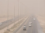
شهدت مدينة الرياض منذ ساعات الصباح الأولى اليوم، هطول أمطار من متوسطة إلى غزيرة، ولا تزال السماء ملبدة بالغيوم.
وفي محافظة الغاط شمال منطقة الرياض تساقطت بعض الثلوج تزامنا مع موجة البرد التي تشهدها المناطق.
وكان المتحدث الرسمي للمركز الوطني للأرصاد حسين القحطاني، توقع تساقط الثلوجاليوم، والتي لن تقتصر على مرتفعات تبوك وحائل، بل تمتد إلى شمال منطقة الرياض ومنطقة القصيم، في ظل استمرار تأثر عدد من مناطق المملكة بحالة جوية باردة.
يذكر أن المركز الوطني للأرصاد توقّع في تقريره عن حالة الطقس هذا اليوم (الخميس)، استمرار هطول أمطار رعدية متوسطة إلى غزيرة تؤدي إلى جريان السيول مصحوبة بزخات من البرد، ورياح نشطة على أجزاء من مناطق: الشرقية، الرياض، القصيم، وتكون خفيفة إلى متوسطة على أجزاء من مناطق: الحدود الشمالية، الجوف، حائل، وكذلك على الأجزاء الجنوبية الغربية من المملكة مع فرصة تكون الضباب على أجزاء من تلك المناطق.
وبين المركز أن حركة الرياح السطحية على البحر الأحمر، شمالية غربية إلى شمالية شرقية بسرعة 25-50 كم/ساعة وعلى الجزء الجنوبي بسرعة 15-35 كم/ساعة تصل إلى 60كم/ساعة مع تكون السحب الرعدية الممطرة، وارتفاع الموج من متر ونصف إلى مترين ونصف على الجزء الشمالي والأوسط ومن نصف المتر إلى متر ونصف يصل إلى مترين ونصف مع تكون السحب الرعدية الممطرة على الجزء الجنوبي، وحالة البحر متوسط الموج إلى مائج على الجزء الشمالي والأوسط وخفيف إلى متوسط الموج يصل إلى مائج مع تكون السحب الرعدية الممطرة على الجزء الجنوبي.
وعلى الخليج العربي ستكون حركة الرياح السطحية شمالية غربية إلى غربية بسرعة 25-50 كم/ساعة تصل إلى أكثر من 60 كم/ساعة مع تكون السحب الرعدية الممطرة، وارتفاع الموج من متر ونصف إلى مترين ونصف يصل إلى أعلى مترين ونصف مع تكون السحب الرعدية الممطرة، وحالة البحر متوسط الموج إلى مائج.
The city of Riyadh has witnessed, since the early hours of this morning, rainfall ranging from moderate to heavy, and the sky remains overcast.
In the Al-Ghat governorate north of the Riyadh region, some snow has fallen coinciding with the cold wave affecting the areas.
The official spokesperson for the National Center of Meteorology, Hussein Al-Qahtani, predicted snowfall today, which will not be limited to the highlands of Tabuk and Hail, but will extend to the northern region of Riyadh and the Qassim region, amid the continued impact of several areas in the Kingdom by a cold weather system.
It is worth mentioning that the National Center of Meteorology predicted in its weather report for today (Thursday) the continuation of moderate to heavy thunderstorm rains leading to flash floods, accompanied by hail showers, and active winds in parts of the regions: Eastern, Riyadh, Qassim, and light to moderate winds in parts of the regions: Northern Borders, Al-Jawf, Hail, as well as in the southwestern parts of the Kingdom with a chance of fog formation in parts of those areas.
The center indicated that the surface wind movement over the Red Sea is from the northwest to the northeast at a speed of 25-50 km/h, and in the southern part at a speed of 15-35 km/h, reaching 60 km/h with the formation of thunderstorm clouds, and wave heights ranging from one and a half meters to two and a half meters in the northern and central parts, and from half a meter to one and a half meters reaching two and a half meters with the formation of thunderstorm clouds in the southern part, while the sea condition is moderate to rough in the northern and central parts and light to moderate reaching rough with the formation of thunderstorm clouds in the southern part.
In the Arabian Gulf, the surface wind movement will be from the northwest to the west at a speed of 25-50 km/h, reaching more than 60 km/h with the formation of thunderstorm clouds, and wave heights ranging from one and a half meters to two and a half meters, reaching over two and a half meters with the formation of thunderstorm clouds, and the sea condition is moderate to rough.