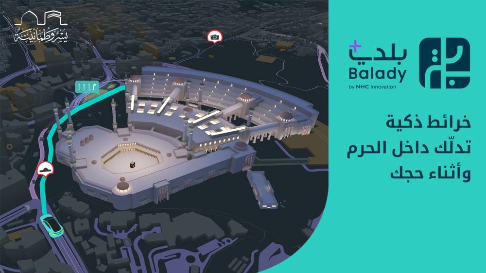
أطلق تطبيق «بلدي+» التابع لـ NHC Innovation تجربةً رقمية مبتكرة ضمن موسم حج 1446هـ، بالشراكة مع الهيئة الملكية لمدينة مكة المكرمة والمشاعر المقدسة، تهدف إلى تسهيل رحلة ضيوف الرحمن داخل المشاعر عبر خرائط تفاعلية دقيقة تعكس الواقع الميداني، وتُسهم في تحسين جودة الخدمات البلدية المقدمة.
ويأتي هذا التعاون في إطار استراتيجية «بلدي+» الرامية إلى تحسين تجربة المستخدم ورفع كفاءة الخدمات البلدية، من خلال دمج الخرائط التفصيلية للمشاعر المقدسة داخل التطبيق، بما يراعي خصوصية المكان وقدسيته، ويمنح الحجاج وسيلةً رقمية موثوقة لمتابعة رحلتهم من لحظة الوصول حتى أداء المناسك.
وقد تم تطوير «بلدي+» بسواعد وطنية ليقدم تجربة خريطة تفاعلية بواجهة ثلاثية الأبعاد، ومحتوى محلي متقن يواكب تغيّرات المدن ويعكس واقعها الحقيقي. كما يوفِّر خدمات تنقّل ذكية تتضمن معلومات لحظية حول الطرق والمواقع والخدمات، بالإضافة إلى التوجيه داخل المراكز التجارية، والتنبيه بوجود المطبات والعوائق والطرق المغلقة، مع دمج بيانات من الجهات الحكومية والمجتمع المحلي
وخلال موسم الحج، عمل فريق «بلدي+» على تحديث أكثر من 11 ألف معلم على الخريطة. تشمل الحرم، ومداخله ومخارجه، وكافة الطرق المحيطة به، ومسارات الوصول إليه والمغادرة منه. بالإضافة إلى المستشفيات، والمراكز الصحية، ومواقع الهلال الأحمر، والمشارب، ودورات المياه، والطرق المحيطة به بأكثر من 160 موقعًا. كما تم تضمين 567 محطة نقل عام (للقطارات والحافلات) لتسهيل حركة تنقل الحجاج، إلى جانب 2,250 نقطة تمثل الفنادق والمخيمات لتيسير وصول الحجاج إلى مقار إقامتهم. وقد شملت التحديثات أيضًا جسر الجمرات ومداخله ومخارجه ومسارات المشاة، كما سيتم عكس جميع الإغلاقات المرورية على الخريطة لدعم خطط إدارة الحشود وضمان سلامة الحركة والتنقل.
وإلى جانب ذلك، تتضمن الخرائط تنبيهات لحظية وخدمات ذكية مثل الأذكار، ومواقيت الصلاة وإمكانية الوصول إلى المصحف الشريف دون الحاجة إلى اتصال بالإنترنت، بما يُسهم في تعزيز سهولة تنقُّل الحجاج، حيث يمكن تحميل التطبيق عبر الرابط: https://balady.go.link/kOJXF
وتُعد هذه الخطوة امتدادًا لالتزام «بلدي» بدورها كممكِّن وطني للمدن الذكية، وتجسيدًا لرؤية السعودية 2030 نحو تحقيق بيئة حضرية أكثر كفاءة واستجابة لاحتياجات السكان والزوار، كما تدعم توسيع نطاق الخدمات الرقمية للجهات الحكومية ضمن خريطة موحدة ذكية تصل إلى المستخدم في أي وقت ومن أي مكان.
The "Balady+" application, affiliated with NHC Innovation, has launched an innovative digital experience during the Hajj season of 1446 AH, in partnership with the Royal Commission for the City of Mecca and the Holy Sites. This initiative aims to facilitate the journey of the guests of Allah within the holy sites through accurate interactive maps that reflect the ground reality, contributing to improving the quality of municipal services provided.
This collaboration comes as part of the "Balady+" strategy aimed at enhancing user experience and increasing the efficiency of municipal services by integrating detailed maps of the holy sites within the application, taking into account the sanctity and privacy of the place, and providing pilgrims with a reliable digital means to track their journey from the moment of arrival until the performance of rituals.
"Balady+" has been developed by national efforts to offer an interactive map experience with a three-dimensional interface and well-crafted local content that keeps pace with urban changes and reflects their true reality. It also provides smart mobility services that include real-time information about roads, locations, and services, in addition to navigation within shopping centers, alerts about bumps, obstacles, and closed roads, while integrating data from government entities and the local community.
During the Hajj season, the "Balady+" team worked on updating more than 11,000 landmarks on the map. This includes the Grand Mosque, its entrances and exits, all surrounding roads, and access and departure routes. Additionally, it covers hospitals, health centers, Red Crescent locations, water stations, restrooms, and surrounding roads with over 160 locations. The updates also included 567 public transport stations (for trains and buses) to facilitate the movement of pilgrims, along with 2,250 points representing hotels and camps to ease pilgrims' access to their accommodations. The updates also encompassed the Jamarat Bridge and its entrances and exits, as well as pedestrian pathways, and all traffic closures will be reflected on the map to support crowd management plans and ensure safe movement and transportation.
Moreover, the maps include real-time alerts and smart services such as dhikr, prayer times, and access to the Holy Quran without the need for an internet connection, which contributes to enhancing the ease of movement for pilgrims. The application can be downloaded via the link: https://balady.go.link/kOJXF
This step is an extension of "Balady's" commitment to its role as a national enabler for smart cities and embodies Saudi Vision 2030 towards achieving a more efficient urban environment that responds to the needs of residents and visitors. It also supports the expansion of digital services for government entities within a unified smart map that reaches users anytime and anywhere.